
Stop Permit Delays. Get a Reviewer-Ready Site Plan in 24 Hours
Your city needs a site plan before it approves your permit. We build it for you — accurate, complete, and ready to submit. Starting at $89.
Accepted Across 40+ Cities
24-Hour Turnaround
Autodesk-Certified Drafters
100% Permit Approval Guarantee
The Permit Is Waiting. The Site Plan Is Holding Everything Up.
You have a contractor scheduled. You have materials on order. And the city just sent back a correction letter.
Missing setback dimensions. Unlabeled easements. A FEMA flood reference that was never on the drawing. Utility connections shown as “connected” instead of mapped.
Each correction adds 4–6 weeks to your timeline. Your contractor moves to another job. Your construction window closes. And you’re still in revision cycles.
This is the most common reason permits get delayed — not zoning violations, not design problems. Documentation gaps.
A permit-ready site plan answers the reviewer’s questions before they’re asked.
That’s what we build.
WHY 70% OF FIRST SUBMISSIONS FAIL
You're Not Losing Permits to Bad Projects. You're Losing Them to Missing Details.
The city doesn’t care that your deck is beautiful or your ADU is well-built. The plan reviewer is checking a list. And if one item is missing, the answer is “Rejected — please resubmit.”
Here’s what that actually costs you:
The Correction Letter Nobody Warns You About
You submit your application. Three weeks later, you receive a PDF with language like:"Setback dimension missing from side property line." "Easement shown without recorded instrument number." "FEMA flood panel number not referenced."Each one of those sends you to the back of the queue. In cities like Austin, Phoenix, Charlotte, and Seattle, a resubmission cycle is 4–8 weeks. You don't just lose days — you lose your contractor slot.
The Contractor Domino Effect
Your crew is staged. Materials are ordered. Then the permit stalls. Your contractor takes the next available job. You're suddenly 6–10 weeks behind schedule — and paying for materials sitting in a driveway.This isn't hypothetical. This is what happens to homeowners who use DIY tools, offshore drafters, or national template services that don't know your city's rules.
Generic Templates Don't Know Local Code
A national software tool doesn't know:Austin's Watershed Protection requirements Seattle's tree canopy ordinance and dripline setback rules Phoenix's impervious surface caps Denver's Stormwater Management criteria Charlotte's accessory structure setback variations by zoning districtWe do. Because we've pulled plats, read correction letters, and delivered approved plans in those exact cities.
Reviewers Reject Ambiguity — Every Time
"Approximate" dimensions. "Utility area" instead of a recorded easement reference. A flood zone box left blank because the property is in Zone X (which still requires the FEMA panel number). These are automatic red flags to any experienced plan reviewer.Our plans are designed to answer every reviewer question before they ask it.
PRICING — FLAT FEE, NO SURPRISES
Fixed Pricing Built Around What Your Project Actually Needs
We don’t charge by the hour. We don’t bill for revisions. You know exactly what you’re paying before you order.
Basic Site Plan
$89
- Property Lines
- Lot Dimensions
- Primary Structure Roofline
- North Arrow
- Scale Bar
- Parcel ID
- Enhanced Compliance for Permits
Standard Site Plan
$119
- Everything in Basic PLUS
- Driveway & Sidewalks
- Fences & Trees
- Swimming Pool
- Accessory Structures
- Shed, Deck, Patio
- Measurements Between Major Features
Gold Site Plan
$159

- Everything in Standard PLUS
- Landscaping Paths
- Shrubs
- Lawn
- Well & Septic System
- Parking Spaces
- Enhanced Compliance for Permits
Platinum Site Plan
$250

- Everything in Premium PLUS
- Additional New Structures
- Topographic Contour Lines
- Vicinity Map
- Graphic Scale
- DWG Source File
- Rush Order Available – Get It in Less Than 12 Hours!
Testimonials

We’ve delivered top-quality site plans for homeowners, builders, and land developers—and they keep coming back for more!
Our Simple 3-Step Process
Get Your Permit-Ready Site Plan in No Time
Select Your Site Plan
Choose the package that best fits your needs, from basic site plans to detailed permit-ready drawings.
Enter Property Details
Provide the property address and upload any relevant documents or special requests.
Receive Your Site Plan
Get your professionally drafted site plan delivered straight to your inbox within 24 hours—or opt for our rush service for even faster turnaround!
We Handle the Site Plan. You Handle the Project.
You don’t need to become a zoning expert. You don’t need to learn Phoenix’s eave projection rules, Austin’s watershed overlay, or Denver’s drainage manual.
You need one thing: a site plan that passes review the first time.
Here’s how it works:
1. Upload your address. No site visit needed. We pull parcel data, county GIS records, and satellite imagery.
2. We build your plan. Setbacks measured correctly. Easements with recorded instrument numbers. FEMA flood panel references. Utility connection points. Drainage flow arrows. Everything the reviewer’s checklist requires.
3. You receive a permit-ready PDF within 24 hours. Attach it to your permit application and submit.
If the city asks for changes, we revise for free. No hourly billing. No back-and-forth on cost.
Get Your Site Plan Now → Starting at $89 · 24-Hour Delivery · Free Revisions
Site plans for Residential Permits
Ensure compliance when making changes to your home or property. Our site plans are ideal for:
- Adding a garage or shed
- Building a deck, pergola, or porch
- Installing fences or retaining walls
- Constructing a swimming pool
- Tree removal permits
- Demolition permits
Site plans for Commercial & Construction Permits
Our detailed site plans support various utility and infrastructure projects, including:
- Commercial site plans for new buildings
- Construction permits for expansions and modifications
- Parking lot design and ADA compliance
- Paving, resealing, and restriping permits
- Signage permits for businesses
Site plans for Utility and Infrastructure Permits
Our detailed site plans support various utility and infrastructure projects, including:
- Driveway permits and curb cuts
- Sidewalk construction and modifications
- Sewer and water connection permits
- Excavation and grading approvals
Site plans HOA and Special Permits
If your project requires approval from an HOA or special permits, we’ve got you covered:
- HOA permit submissions for modifications
- Conditional use permits for zoning exceptions
- Sign permits for businesses or real estate
- Tree removal and environmental compliance
Save Time & Money
Many permit applications don’t require an engineer, surveyor, or architect stamp—our professionally drafted site plans are a cost-effective solution. We use
- Satellite imagery
- County parcel maps
- GIS data & client-provided sketches to create accurate, scalable site plans without a site visit!
- Get Started Today!
- Starting at $89
- Fast turnaround time
- 100% satisfaction guarantee
Your Permit Is Not a Drawing Problem. It's a Knowledge Problem.
Most site plans fail because the person who drew them never read a correction letter. We have. Hundreds of them. That’s why SitePlans.us was built by a licensed Professional Land Surveyor — not a drafting app, not a freelance marketplace, not a template generator.
No survey required
Most residential permits don't need one. We use your county-recorded plat and deed description to produce legally accurate dimensions — the same documents a surveyor would start with. If a boundary dispute exists, we'll flag it before you pay.
No site visits No Waiting
We pull your recorded plat, county GIS data, and FEMA flood maps remotely — so your 24-hour clock starts the moment you upload your address, not when we can schedule a visit.
No zoning homework on your end
Setback tables, tree ordinances, impervious surface caps, ADU size limits — we research your city's current rules before we draw a single line. You don't learn code. We already know it.
Fixed pricing $89–$249
No hourly billing. No surprise revision fees. No "scope creep" invoices. You know exactly what you're paying before you order — and free revisions are included if the city asks for changes.
Reviewer Ready 24-hour turnaround
Not a draft. Not a template. A complete, dimensioned, annotated PDF built to your city's exact submittal checklist — delivered the same day or next morning, ready to upload to your permit portal.
Get a reviewer-ready site plan in 24 hours. Flat fee. Free revisions. Nationwide.
Permit-Ready Site Plans for Every City & County Across the USA
CITY COVERAGE — WE KNOW YOUR SPECIFIC RULES
Your City Has Its Own Checklist. We've Read It.
Generic site plan services deliver the same template whether you’re in Phoenix or Portland. We don’t.
We maintain city-specific knowledge for over 200 municipalities, including unique requirements for:
- Austin, TX — Watershed Protection Zone overlays, impervious cover limits, tree survey requirements
- Seattle, WA — Tree canopy ordinance, stormwater flow control, DADU size caps
- Phoenix, AZ — Impervious surface limits, shade structure rules, lot coverage by zoning district
- Charlotte, NC — Mecklenburg County plat standards, accessory structure setbacks, ADU parking
- Denver, CO — Stormwater management criteria, floodplain overlay rules
- Los Angeles, CA — ADU state vs. local rules, fire access, hillside grading requirements
- Raleigh, NC — Tree conservation ordinance, stormwater overlay, setback exceptions
- Portland, OR — ADU owner-occupancy rules, impervious surface, accessory structure caps
- Miami, FL — FEMA flood zone complexity, wind-load notes, setback overlays
- Chicago, IL — Zoning district variation requirements, impervious surface, ADU rules
And every other state and city nationwide.
Browse our city-specific permit guides for local setback rules, ADU ordinances, tree preservation requirements, and common rejection triggers:
- Jacksonville FL
- Miami FL
- Fort Lauderdale FL
- St. Petersburg FL
- Sarasota FL
- Cape Coral FL
- Chattanooga TN
- Savannah GA
- Fort Myers FL
- Las Vegas NV
- Jacksonville FL
- Rutland VT
- Scottsdale AZ
- Mesa AZ
- Chandler AZ
- Gilbert AZ
- Tucson AZ
- Las Vegas NV
- Raleigh NC
- Durham NC
- Charleston SC
- Greenville SC
- Knoxville TN
- El Paso TX
Case Studies: Real Permit Approvals How We Help Homeowners & Builders Get Approved
Read More Case Studies — Projects Approved Across the Country
Case Studies
- Charlotte ADU Approved After Two National Service Rejections
- Phoenix Detached Garage: First Submission Approval
- Seattle DADU: Tree Ordinance and Stormwater Compliance
- Austin Pool Permit: Watershed Protection Zone Compliance
- Denver Addition: Stormwater Management and Floodplain Notes
Read All Real Site Plan Approval Case Studies here
WHO WE ARE — THE EXPERIENCE BEHIND EVERY PLAN
We're Not a Just Generic Drafter or Software Company. We're Land Professionals Who Built a Service.
There are dozens of site plan services online. Most of them are:
- Drafting apps where you draw your own plan from a satellite image
- Freelance marketplaces where you don’t know who’s drawing your plan or what codes they’ve read
- National template services that deliver the same boilerplate PDF regardless of your city’s requirements
SitePlans.us is none of those things.

Meet Raja — Professional Land Surveyor, Founder
"I spent over a decade doing boundary surveys, infrastructure work, and field measurement. I sat across from plan reviewers. I read correction letters. I watched homeowners lose months because a drafter who'd never held a survey rod didn't know what 'measured from the furthest projection' meant. I built SitePlans.us for one reason: to take the land knowledge I developed in the field and use it to protect homeowners from the bureaucratic traps that kill projects before they start. Every plan we deliver is one I'd be comfortable putting my surveyor's seal of quality behind."— Raja | Professional Land Surveyor | 15+ Years | Residential US Land Development Specialist | International Infrastructure Background
What That Means For Your Plan
When a Professional Land surveyor reviews your property data, you’re not just getting a drawing. You’re getting:
- Plat research that catches discrepancies between GIS data and recorded deeds
- Setback measurements taken from the correct legal reference point (the eave, not the foundation)
- Easement citations pulled from actual county records — with book and page numbers
- Flood zone verification from FEMA's current FIRM database — including the panel number even in Zone X
- Local code review specific to your city's current submittal checklist
This is what separates a plan that gets approved from one that gets rejected.
FREQUENTLY ASKED QUESTIONS
Every Question You Have Before Ordering — Answered Directly
For the vast majority of residential permit projects — garages, ADUs, decks, pools, additions — no survey is required. We use your county-recorded plat, deed description, and verified GIS data to produce an accurate plan. If your property has a known boundary dispute or missing recorded documents, we will flag it before you pay — and recommend a boundary survey only if genuinely necessary.
Yes. We regularly prepare permit-ready site plans for sheds, detached garages, swimming pools, decks, patios, room additions, accessory dwelling units (ADUs), and new residential construction.
After checkout, you submit your property address and project details. We research the parcel, prepare the site plan, and deliver a PDF ready for permit submission. Most residential projects are completed within 24 hours.
Yes, most cities require a site plan (sometimes called a plot plan) for any permit that involves new construction, additions, decks, garages, sheds, pools, or ADUs. The site plan shows your property lines, existing structures, setbacks, and proposed construction so the city can verify code compliance.
Most residential site plans are delivered within 24 hours. If you need it faster, we offer a rush option that delivers your plan in as little as 12 hours. This is significantly faster than traditional drafting services that often take 1–3 weeks
A survey records what exists legally on your property (boundaries, easements). A site plan shows what you propose to build (new structure, setback compliance). Most permits require a site plan, not a full survey. Surveys are typically only required for legal boundary disputes, subdivisions, or when the permit office specifically asks for one.
Technically yes, but homeowner‑drawn plans are a leading cause of permit rejections. Missing dimensions, incorrect setbacks, unclear utility callouts, and improper scale are common errors. A professionally prepared plan reduces the risk of revision cycles and weeks of delays.
A complete site plan should include property boundaries with dimensions, existing structures, proposed construction, setback lines, easements, utility locations, north arrow, scale, and driveway/parking areas. The exact requirements vary by city, so we tailor each plan to your local building department.
We prepare site plans for homeowners, contractors, and builders throughout Texas and across the United States. Requirements vary by jurisdiction, so each plan is prepared using local parcel data and permit submission standards.
If a site plan is rejected because of an error on our side, we will revise it at no additional cost. Our goal is to provide permit-ready plans designed to reduce revision cycles caused by missing or unclear information.ntent
Send us the correction letter. We review every item the plan reviewer flagged and revise your plan to address each one — at no additional charge. This applies to every package, with no time limit. No hourly billing, no argument, no questions asked.
Yes. Every plan we produce is drafted to meet the specific submittal standards of your city or county. We maintain current knowledge of local checklists and update our templates when municipalities change their requirements. If a reviewer asks for an additional note or item we didn’t include, we add it at no charge.
Our Revision-Only service ($89) is built for exactly this situation. Send us your existing plan and the correction letter. We fix every item the reviewer flagged. Same 24-hour turnaround, same quality standards.
Our primary focus is residential — single-family, ADU, accessory structures. For commercial projects with residential components (e.g., mixed-use ground floors with residential above), contact us directly for a custom quote.
You receive a PDF formatted to the submittal dimensions and scale required by your city (typically 24″×36″ or 11″×17″). If your city requires a specific file format, CAD export, or additional sheets, let us know at checkout.
98% First‑Time Approval. You Read That Right.
Most homeowners wait weeks for a rejection. Our plans are built to pass on the first submission – because we already know what reviewers flag.
Upload Your Address at 9 AM. Get a Reviewer‑Ready Plan by Tomorrow.
Stop Researching. Start Uploading. We’ll Handle the Rest.
Your Contractor Is Waiting. Don’t Let a Missing Note Cost You 4 Weeks.
One missing setback or easement reference pushes your permit to the back of the queue. We catch it before you submit.
WHAT'S INCLUDED — AND WHY EACH ITEM MATTERS
Every Item on This List Has Appeared in an Actual Correction Letter
We didn’t invent this checklist. Plan reviewers across the country taught it to us — one rejection letter at a time.
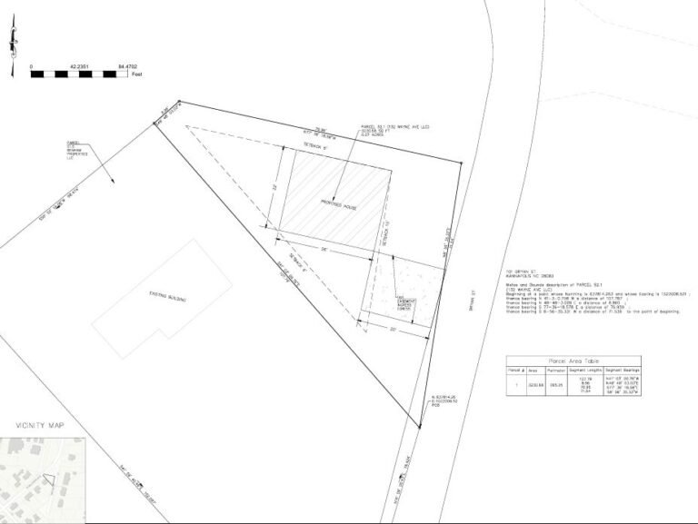
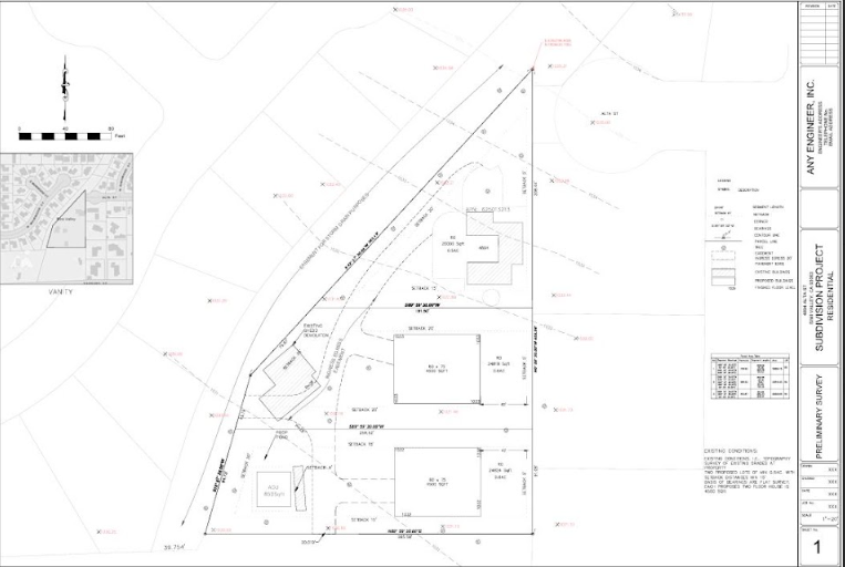
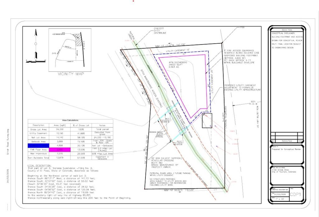
- Property Lines from Recorded Plats — Not GIS
- Setbacks Measured from the Eave — Not the Foundation
GIS data is often rounded, interpolated, or outdated. We pull your legal property dimensions from county-recorded plats and deed descriptions. Plan reviewers cross-reference these. If your dimensions are off by even a foot, it raises questions.
This is the single most common rejection trigger we see. City codes measure setbacks from the furthest building projection — which is the roof overhang or gutter, not the foundation wall. We measure correctly. Every time.
- Easements with Recorded Instrument Numbers
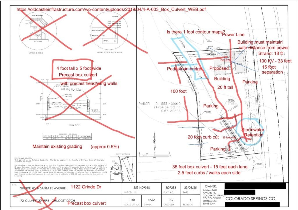
Showing a utility easement line on your plan is not enough. Reviewers require the document reference — the book and page number from county records. We pull those records and cite them correctly on your plan.
- Flood Zone Classification + FEMA Panel Number
Even if your property is in Zone X (low risk), most cities require the FEMA flood insurance rate map panel number on the site plan. We include it on every plan, automatically. This alone eliminates one of the most common “minor” rejections.
- Lot Coverage and Impervious Surface Calculation
Many cities cap the percentage of your lot that can be covered by structures and hardscape — commonly 40%, 45%, or 50% depending on zoning. We calculate your existing and proposed coverage and show the math. Reviewers want to see the numbers, not just the drawing.
- Drainage and Stormwater Notes
Any project that alters existing drainage patterns — a new structure, an expanded driveway, a pool deck — requires flow arrows and retention language in most jurisdictions. We include the required stormwater notes per your city’s standards.
- Tree Preservation Notes (Where Required)
Protected trees must be identified by species, trunk diameter, and dripline. Cities like Austin, Seattle, Raleigh, and Portland require specific mitigation language and canopy calculations. We add the required notes based on your local tree ordinance — not a generic template.
- ADU-Specific Requirements
ADU regulations vary dramatically by city. We verify and show: maximum unit size, height limits, required parking spaces, setback variations, owner-occupancy notes, and utility separation requirements — all per your city’s current ADU ordinance.
- Driveway Width, Turning Radii, and Fire Access
Minimum driveway widths, throat distances, and fire department access requirements must be dimensioned on the plan in most jurisdictions. We include them so the reviewer — and the fire marshal — don’t have to ask.
- North Arrow and Engineering Scale
This sounds obvious. But missing either of these will get your plan rejected before a reviewer reads a single dimension. We include both on every sheet, correctly oriented and scaled.
- Utility Connection Points
Water, sewer, gas, and electrical connection locations — shown with correct notation so the reviewer doesn’t have to ask the building department to cross-reference with the utility company.
- Existing vs. Proposed — Clearly Differentiated
We use different line types, hatching, and labeling to clearly distinguish what exists today from what is proposed. This is a basic professional standard that many DIY and template plans fail to follow — and reviewers notice immediately.
REAL PROJECTS, REAL APPROVALS
What Happens When the Plan Is Actually Right the First Time
The 7 Most Common Rejection Reasons — And How We Prevent Each One
Plan reviewers across the country reject for the same reasons, over and over. Here’s what they say, and why our plans eliminate every one of these before submission.
Rejection #1: “Setback dimension missing from side/rear property line.” → We pre-draw and dimension all setbacks — from every property line, from the eave — on every plan. No guesswork, no omissions.
Rejection #2: “Easement shown on plan without recorded instrument reference.” → We pull the recorded document from county records and add the deed book and page number to every easement shown.
Rejection #3: “FEMA flood zone reference missing. Panel number required.” → We verify flood zone classification from the current FIRM database and include the panel number on every plan, regardless of zone classification.
Rejection #4: “Impervious surface calculation not provided.” → We calculate total impervious surface (existing + proposed) and show the math on the plan face. Reviewers see the numbers immediately.
Rejection #5: “Scale not indicated” or “North arrow missing.” → Both appear on every plan we deliver. These are non-negotiable professional standards, not optional additions.
Rejection #6: “Tree protection notes not included per [City] Tree Ordinance.” → We research your specific city’s tree ordinance and include the required language, species identification, and dripline notes for any regulated trees on or near the project area.
Rejection #7: “Drainage plan required for projects altering stormwater flow.” → We include flow arrows, drainage direction notes, and required stormwater language for any project that adds or modifies impervious surface.
Everything You Need to Navigate the Permit Process — In One Place
We don’t just deliver plans. We publish the knowledge that helps homeowners and contractors understand what they’re up against — before they submit.
Guides For Homeowners
- The Complete Guide to Residential Site Plans — What’s required, why it matters, how to read one
- ADU Permit Guide by State — Current rules for accessory dwelling units in all 50 states
- How to Read a Correction Letter — Translating reviewer language into actionable fixes
- Setback Rules Explained — Foundation vs. eave measurements and why it matters
- FEMA Flood Zones for Homeowners — What Zone X, AE, and AH mean for your permit
- Tree Ordinance Guide — Which cities have them and what they require on your site plan
- Impervious Surface Calculator Guide — How to calculate lot coverage for your project typeFor H
Your Permit Is 24 Hours Away. Your Next Correction Letter Doesn't Have to Happen.
Every Permit Starts With a Site Plan. Every Project Type Has Its Own Checklist.
A garage permit in Sacramento is not reviewed the same way a pool permit in Jacksonville is. An ADU in Raleigh has a different size cap than an ADU in Austin. A fence on a corner lot needs a sight triangle notation that an interior lot fence doesn’t.
The permit type determines what the reviewer checks. The city determines what the reviewer requires. A site plan that doesn’t account for both comes back for corrections.
Below is every project type we draft site plans for — and what makes each one different from the rest.
Site Plan by Project Type
Comparing options and ready to order. Here’s what separates a plan that passes from one that comes back — and why the difference isn’t speed or price.
Your permit application says “site plan required.” This is what fills that requirement — drafted to your city’s checklist, delivered in 24 hours.
Every residential permit type covered in one place. Setbacks, lot coverage, flood zone, tree protection — verified for your city before a line is drawn.
The most code-sensitive residential project type. Size caps, height limits, lot coverage, state preemption provisions — we verify your city’s current ADU standard before drafting begins.
Setbacks measured to the eave, not the foundation. Easements checked before the footprint is placed. Lot coverage calculated with every hardscape element included.
Barrier notation, equipment pad location, setbacks to the water’s edge, drainage direction — the elements generic plans miss and reviewers flag every time.
Existing nonconforming setbacks documented. Combined lot coverage calculated across decades of incremental improvements. Flood zone checked. Built to clear review on the first cycle.
Simple project. But the rear utility easement, the eave overhang on that prefab, and the driveway missing from the lot coverage math are why shed permits come back more than they should.
Attached decks extend the primary structure’s setback measurement to the deck edge — not the house wall. Concrete patios are 100% impervious. Covered structures carry height implications. We account for all of it.
Three things reviewers check: property line location, easement clearance, and front yard vs. rear yard height limits. Three things most plans get wrong. We get them right before you submit.
For contractors and builders pulling permits across multiple jurisdictions. Jurisdiction-specific research, 24-hour turnaround, same-day available for qualifying orders, white-label title blocks on request.
Half the permit guides you’ll find online still say “DCRA.” That agency hasn’t issued building permits since October 2022. If the service drafting your site plan is still using outdated DC permit terminology, the plan they produce probably reflects outdated DC permit standards too.
Site Plan by Question
Most residential permits don’t require a surveyor’s stamp. Here’s how to verify what your city actually requires — and what you’re paying for if you order the wrong one.
Four options. What each costs. How long each takes. Which one most homeowners pulling a residential permit actually need.
A plot plan for a residential building permit is a scaled drawing of your lot showing what exists, what’s proposed, and how far everything sits from the property lines. Most permit offices accept a non-certified version for fences, sheds, pools, decks, additions, and ADUs. We draw it from your address. You get a PDF in days, not weeks.
Most fence permit rejections have nothing to do with the fence. They have to do with the drawing. Missing right-of-way clearance. No setback dimension to the property line. A lot boundary that doesn’t match the recorded deed. We draw fence permit site plans from your parcel data — not from a satellite screenshot — and check the specific elements your permit office flags before the plan leaves our desk. From Basic Starting from $89.
Driveway Permit Site Plan
A driveway permit site plan is one of the lighter residential permit drawings — until the property is a corner lot, the curb cut is near an intersection, or the new driveway pushes the lot’s impervious coverage past the zoning limit. We check all three before drawing anything. From $89.
Site Plan Near to Your City
We’ve documented specific reviewer requirements, correction letter patterns, and local code details for 30+ cities. Every plan we draft is researched to that city’s actual checklist — not a generic residential template.
Texas — Austin | Dallas | Fort Worth | San Antonio | Plano
California — Sacramento | Los Angeles | San Diego | San Jose | Fresno
Florida — Jacksonville | Tampa | Orlando | Miami
Southeast — Raleigh | Charlotte | Atlanta | Nashville | Savannah
Mountain West — Denver | Phoenix | Las Vegas | Colorado Springs
Pacific Northwest — Seattle | Portland
Don’t see your city? We cover all 50 states. Every order includes jurisdiction-specific research.
- No site visit
- Free revisions
- No survey required
- Nationwide coverage
- 100% satisfaction guarantee
Platinum Site Plan
Highest Acceptance Rate for New Homes, Commercial & Complex Projects- Highest acceptance rate
- 24‑hour turnaround , No on‑site visit , Expert support
- Prepared by Professional Autodesk Certified Civil 3D Drafters