Home » Raleigh Site Plan
The Neuse River buffer runs through your backyard. There's a 10-inch white oak 40 feet from the proposed addition. Your lot was recorded in 1998. Any one of those facts changes what Raleigh's reviewers need to see — and none of them show up in a generic site plan template.
The plan looked complete. It had a footprint, setback dimensions, a north arrow. The homeowner submitted through the Permit and Development Portal and waited.
Three weeks later: correction comments. Stormwater flagged missing impervious surface line items. Urban Forestry flagged a tree conservation area that wasn’t shown. The project contact got a response-to-comments requirement and a resubmittal clock.
The framer had already been scheduled.
Raleigh’s Planning and Development department routes residential permits through concurrent review — Building, Stormwater, Urban Forestry, Zoning, and sometimes Historic. Each division can independently issue comments. A gap in the stormwater section doesn’t just delay stormwater clearance; it delays everything running alongside it.
We build plans that close those gaps before the portal ever sees them.
Give us your address. We pull your Wake County parcel data, check your zoning district in iMAPS, identify your impervious limits based on when your lot was recorded, locate trees 10 inches DBH and above, flag any Neuse River riparian buffer overlap, and deliver a PDF sized for Raleigh’s actual checklist.
- 24-hour turnaround on most residential projects
- Free revisions if the city issues correction comments
- Affordable Fixed prices — $89 to $249
What Raleigh's Review Process Actually Looks Like
Most homeowners think of a permit as a single approval. Raleigh runs it differently.
When you submit through the Permit and Development Portal, the application fans out to multiple divisions at once: Building/Structural, Stormwater Management, Urban Forestry, Zoning, and — depending on location — potentially the Raleigh Historic Development Commission. Each division reviews independently. Each can issue comments. And because the reviews run concurrently, a correction from Stormwater sits open in the system while Building waits.
That’s what makes an incomplete Raleigh site plan so costly. It doesn’t delay one review. It holds the whole queue.
The most common reasons Raleigh residential permits come back with correction comments:
Impervious surface calculations missing or incomplete. Raleigh’s Stormwater Division requires existing and proposed impervious surface figures shown as individual line items on your plot plan — house footprint, driveway, shed, deck, and patio listed separately, not combined. Whether your lot has a per-lot maximum tied to the recorded plat or falls under the city’s general residential limits, those numbers have to appear before stormwater review closes.
Lot recording date determines your impervious rules. Raleigh applies different stormwater standards depending on when your lot was created. Lots recorded before May 2001 fall under grandfathered rules with specific per-lot limits. Lots recorded after May 2001 typically carry a maximum impervious surface figure on the recorded plat itself. Submitting without knowing which framework applies — and showing the wrong numbers — produces a stormwater comment on the first cycle.
Tree conservation areas absent. The UDO’s Article 9.1 requires that trees 10 inches DBH and larger be surveyed on regulated development sites. Trees within 50 feet of a thoroughfare and those within 65 feet of a non-vacant property boundary have the highest protection priority. If your project disturbs or comes near these trees and the conservation area isn’t delineated on the plan, Urban Forestry flags it. Removed trees require replacement planting or a payment to the Tree Conservation Fund.
Neuse River riparian buffer not shown. All of Raleigh drains to the Neuse River Basin. The NC DEQ enforces a 50-foot riparian buffer on regulated streams within city limits — Zone 1 (the inner 30 feet) must stay completely undisturbed; Zone 2 (the outer 20 feet) allows only managed vegetation. If your parcel has a stream running through or near it, the buffer boundary has to appear on the plan. Stormwater review will not close without it on affected properties.
Setback dimensions tied to the wrong district standard. Raleigh’s UDO covers five residential zoning districts — R-1, R-2, R-4, R-6, and R-10 — plus the newer Missing Middle-enabled districts and mixed-use overlays. Front setbacks range from 10 to 30 feet depending on district. Applying the wrong figure, or measuring to an incorrect baseline, produces a zoning comment that restarts the clock.
Historic overlay not acknowledged. Properties in Oakwood, Boylan Heights, Mordecai, or any other Raleigh Historic Landmark or district require a Certificate of Appropriateness from the Raleigh Historic Development Commission before the permit application can be filed. If the plan doesn’t reference this or if the RHDC approval isn’t in hand, the application comes back before substantive review begins.
What Raleigh's Correction Comments Look Like
These are the kinds of notes that show up in the Permit Portal when a residential plan goes in incomplete:
“Impervious surface calculations not provided as line items. Per stormwater residential requirements, existing and proposed impervious surfaces must be listed separately — house, driveway, patio, deck, and other hardscape. Resubmit with itemized totals.”
We list every hardscape category individually, with square footage for each and a running total. Stormwater doesn’t want a single combined number.
“Tree conservation area not delineated. Site shows trees greater than 10″ DBH within 65 feet of adjacent non-vacant property boundary. Conservation area boundaries and metes and bounds description required per UDO Article 9.1.”
We locate qualifying trees, draw the conservation area polygons, and add the UDO Article 9.1 notation. Urban Forestry cross-references aerial imagery — we draw what the aerials show.
“Neuse River riparian buffer not shown. USGS blueline stream present on parcel per iMAPS. Zone 1 and Zone 2 buffer extents required on plan prior to stormwater clearance.”
We check iMAPS for blueline stream presence on every parcel near a watercourse. When a buffer applies, we show both zones with correct dimensions.
“Setback shown at 20 feet front yard. Property zoned R-4. Front yard setback for R-4 is 20 feet to building face — confirm measurement is to wall face, not to eave or projection. Clarification required.”
UDO setback measurement rules in Raleigh require precision on what building element you’re measuring to. We note the measurement basis on the plan so there’s no ambiguity for the reviewer.
“Property located within Oakwood Historic District. Certificate of Appropriateness from RHDC required prior to building permit application. Application returned — obtain COA and resubmit.”
If your property is in a historic overlay, we flag it at the outset and note the COA requirement on the plan. You can’t go around it, but you can go in prepared.
“ADU proposed on lot with principal structure. Lot coverage shown at 42%. R-4 district maximum lot coverage is 40%. Revise footprint or provide impervious surface reduction plan.”
We verify lot coverage against UDO district maximums before the plan is finished. For ADUs specifically, we also confirm the proposed unit complies with UDO Section 2.6.3.D accessory dwelling standards.
What Goes Into a Raleigh Site Plan — And Why Each Element Gets Checked
| What We Include | What Raleigh Reviewers Look For |
|---|---|
| Property lines from Wake County recorded plat | Legal dimensions, not GIS approximations. Reviewers check plat book and page. |
| Zoning district identification + applicable setbacks | R-1 through R-10 and overlay districts each carry different front, rear, and side setback rules. We identify yours. |
| Impervious surface line items (existing + proposed) | Stormwater requires individual categories: house, driveway, deck, shed, patio. One combined figure won’t clear review. |
| Lot recording date notation | Pre-May 2001 vs. post-May 2001 determines which impervious framework applies. We note it. |
| Tree conservation area (10″+ DBH trees) | Article 9.1 delineation with metes and bounds description when trees fall within protected proximity zones. |
| Neuse River riparian buffer (Zone 1 + Zone 2) | Shown when a USGS blueline stream appears on the parcel. Zone 1 = inner 30 ft undisturbed; Zone 2 = outer 20 ft managed. |
| Floodplain/flood hazard area notation | Flood-prone soil indicators from iMAPS checked; floodplain boundary shown when applicable. |
| ADU compliance — lot coverage, setbacks, UDO §2.6.3.D | Maximum lot coverage, accessory structure height limits, and ADU-specific standards verified before submission. |
| Historic overlay acknowledgment | Properties in RHDC districts noted with COA requirement flagged for the owner. |
| North arrow, engineering scale, legal description, Wake County PIN | Missing any of these means rejection before substantive review. Included on every sheet. |
| Utility connection points | Raleigh Water connections shown; easements labeled with recorded instrument references. |
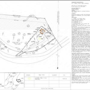
Real Raleigh Case Study – Addition Stalled Six Weeks Over a Stream Buffer
Project type: Rear addition, single-family home, Southeast Raleigh neighborhood (R-4 zoning, lot recorded 1994)
What the homeowner submitted: A plan drawn by a local handyman. Property lines, footprint, two setback dimensions. No impervious surface calculation. No tree notation. No stream reference.
What came back in correction comments:
From Stormwater: “Existing and proposed impervious surface calculations not provided as line items. USGS blueline stream present on parcel — riparian buffer extents (Zone 1 and Zone 2) must be shown before stormwater review can be completed.”
From Urban Forestry: “Two trees 12″+ DBH present within 65 feet of rear property boundary per aerial review. Tree conservation area not delineated. Metes and bounds description of conservation area required.”
The actual problem: A seasonal drainage channel ran along the rear of the property — not a major stream, but blueline on USGS mapping and therefore regulated. The proposed addition sat 38 feet from the channel centerline, putting part of the foundation inside Zone 2.
What we did: Pulled iMAPS, confirmed the blueline stream location, and mapped both buffer zones. The addition footprint was shifted 6 feet toward the house to clear Zone 2. We itemized impervious surface — 1,840 sq ft house (existing) + 320 sq ft addition + 480 sq ft driveway + 96 sq ft front walk = 2,736 sq ft total on a 10,200 sq ft lot, well within the grandfathered-lot limit for a pre-2001 parcel. We located the two rear trees (a 13-inch white oak and a 14-inch willow oak), drew the conservation area polygon, and added the Article 9.1 notation.
Outcome: Stormwater and Urban Forestry both cleared on the resubmission cycle. Building issued the permit 11 business days later. The six weeks lost on the original submission didn’t repeat.
A Note on Raleigh's Missing Middle Reforms
Raleigh’s UDO text changes — TC-5-20 and TC-20-21 — significantly expanded what’s allowed on a residential lot. Duplexes, triplexes, cottage courts, and ADUs are now permitted in zoning districts that were previously single-family only. That’s useful for homeowners who want to add a unit. It also added complexity that wasn’t there five years ago.
ADUs must comply with UDO Section 2.6.3.D — which governs setbacks, height, lot coverage, and use restrictions specific to accessory dwellings. On townhouse lots near high-frequency transit corridors, two ADUs per lot may be permitted. Flag lots created under Missing Middle reforms carry a 1,200 sq ft maximum for the principal structure. Cottage courts require a different site layout altogether.
If your project involves any of these newer categories, the site plan needs to reflect the correct standard — not a generic accessory structure template. We know which text change applies to your project type and district.
Pricing
| Tiers | Price |
|---|---|
| Basic Site Plan — property lines, structures, UDO setbacks, north arrow, scale, Wake County PIN | $89 |
| Enhanced Plan — adds impervious surface line items, tree conservation notation, stream buffer (if applicable), easements, utilities | $149 |
| Premium Plan — adds ADU compliance, historic overlay acknowledgment, complex lot geometry, Missing Middle unit types, grading notes | $249+ |
✅ Free revisions on any city correction comments
✅ 24-hour delivery for standard residential projects
✅ No site visit required — we work from Wake County plat records and iMAPS data
FAQs — What Raleigh Homeowners Ask Before Ordering
Lots recorded before May 2001 fall under Raleigh’s grandfathered residential stormwater rules. Your impervious limit depends on your lot size and zoning district rather than a figure printed on the plat. We identify your category and show the calculation correctly — because submitting the wrong framework produces a stormwater comment even when your numbers are technically fine.
Possibly, and it matters a lot. If that creek is a USGS blueline stream, Raleigh’s Stormwater Division requires the 50-foot Neuse River riparian buffer to be shown on the plan — Zone 1 (inner 30 feet, fully undisturbed) and Zone 2 (outer 20 feet, managed vegetation only). We check iMAPS for blueline stream presence on every parcel. If it’s there, we show both zones. If your proposed structure is within 50 feet of the channel centerline, we flag it before you submit.
At minimum: lot coverage showing the ADU doesn’t push you over your district’s maximum, setback dimensions from all property lines, ADU footprint and height confirmed against UDO §2.6.3.D, and a notation that the unit is a residential accessory use. If you’re near a transit corridor where two ADUs per lot are allowed, or on a townhouse lot, the applicable standard changes. We verify all of it.
Yes. Properties within any Raleigh Historic District or designated as a Historic Landmark require a Certificate of Appropriateness from the Raleigh Historic Development Commission before a building permit application can be accepted. We note the RHDC requirement on the plan, but the COA itself is a separate approval you’ll need from the Commission before submitting to the Permit Portal.
We revise at no additional charge. Send us the comment letter from the Permit Portal and we update the plan to address each item directly. Most correction cycles on plans we draft come down to minor clarifications rather than substantive redesigns.
Raleigh’s iMAPS portal at maps.raleighnc.gov lets you search by address or Wake County PIN to find your zoning district, stream buffer status, and historic overlay designation. For impervious limits on post-2001 lots, the recorded plat typically shows the maximum per-lot figure. For pre-2001 lots, it’s determined by lot size and district. We run this research for every order as part of drafting.
Click below, enter your address, and checkout. We do the rest.
Other North Carolina and Southeast Cities We Cover
SitePlans.us prepares permit-ready plans for homeowners and contractors across North Carolina and nationwide.
North Carolina: Charlotte | Durham | Greensboro | Winston–Salem | Fayetteville | Asheville | Wilmington | Cary | Chapel Hill
Southeast: Atlanta | Nashville | Richmond | Virginia Beach | Charleston SC | Savannah | Jacksonville FL | Tampa
Also serving: Austin | Denver | Phoenix | Las Vegas | Seattle | Portland | Sacramento | San Diego
Not seeing your city? We work in all 50 states — enter your address at checkout.
A Complete Plan Closes Every Review Queue at Once
Based on Raleigh’s Unified Development Ordinance (UDO), Stormwater Residential Permitting requirements, and NC DEQ Neuse River Basin riparian buffer rules as of June 2026. Code references verified against raleighnc.gov and udo.raleighnc.gov.
Official Raleigh Permit Resources
- Planning and Development Customer Service Center — One Exchange Plaza, Suite 400, Raleigh, NC 27601. Phone: (919) 996-2500.
- Raleigh Permit and Development Portal — All residential permit submissions: raleighnc.gov/permits
- Raleigh iMAPS — Zoning, stream buffers, tree conservation, and parcel data: maps.raleighnc.gov
- Unified Development Ordinance (UDO) — Residential districts (Ch. 2), tree conservation (Art. 9.1), riparian buffer standards (§8.5): udo.raleighnc.gov
- Raleigh Stormwater — Residential Permitting — Impervious surface requirements by lot recording date: raleighnc.gov/stormwater
- Raleigh Historic Development Commission (RHDC) — Certificate of Appropriateness for historic district properties: raleighnc.gov/historic
- NC DEQ Riparian Buffer Program — NCAC 02B .0233 Neuse River Basin buffer rules: deq.nc.gov
- Wake County GIS / Parcel Records — Plat books, recorded dimensions, PIN lookups: maps.wakegov.com
Other cities we’ve helped (Sunbelt States):
Phoenix | Tucson | Las Vegas | Denver | Colorado Springs | Austin | Dallas | Houston | Fort Worth | Atlanta | Savannah | Portland | Seattle | Charlotte | Raleigh | Nashville | Orlando | Jacksonville | Tampa | Miami
Don’t see your city? We cover all 50 states. Just enter your address at checkout.
98% First‑Time Approval. You Read That Right.
Most homeowners wait weeks for a rejection. Our plans are built to pass on the first submission – because we already know what reviewers flag.
Upload Your Address at 9 AM. Get a Reviewer‑Ready Plan by Tomorrow.
Stop Researching. Start Uploading. We’ll Handle the Rest.
Your Contractor Is Waiting. Don’t Let a Missing Note Cost You 4 Weeks.
One missing setback or easement reference pushes your permit to the back of the queue. We catch it before you submit.
What San Diego Homeowners Say About Getting Their Permits Approved
Platinum Site Plan
Highest Acceptance Rate for New Homes, Commercial & Complex Projects-
Highest acceptance rate
-
24‑hour turnaround , No on‑site visit , Expert support
-
Prepared by Professional Autodesk Certified Civil 3D Drafters
-
Site Plan Packages
Platinum Site Plan
$380.00Original price was: $380.00.$250.00Current price is: $250.00. Add to cart -
Site Plan Packages
Gold Site Plan
$200.00Original price was: $200.00.$159.00Current price is: $159.00. Add to cart -
Site Plan Packages
Standard Site Plan
$160.00Original price was: $160.00.$119.00Current price is: $119.00. Add to cart -
Site Plan Packages
Basic Site Plan
$100.00Original price was: $100.00.$89.00Current price is: $89.00. Add to cart