
Home » case studies » Mendon, VT Case Study
Case Study: A Wastewater Connection, a 1990s Address Renumbering, and a 1992 Survey That Changed the Plan — Mendon, Vermont
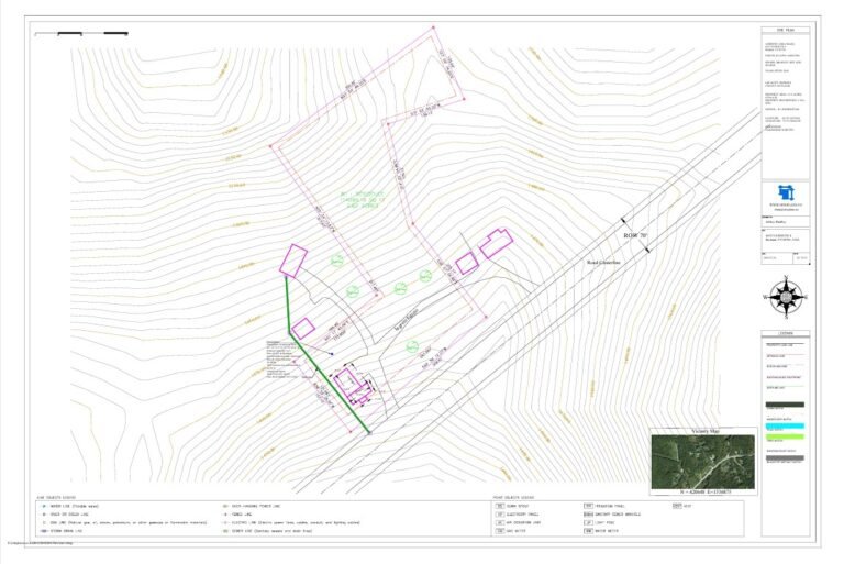
Table of Contents
Project type: Wastewater pipeline connection + garage-to-rental conversion (site plan for permit)
Location: Mendon, Vermont (Rutland County)
Order: #944, placed July 23, 2025
Package: Started as Basic Site Plan & Plot Plan ($89), upgraded to a Gold-tier drainage/utility package ($159), then expanded again for utility integration ($259 total)
Timeline: First delivery in under 31 hours; final revised plan delivered 6 days later, after two rounds of substantive revision driven by the homeowner’s own property records
The Order
On the evening of July 23, 2025, Jeffrey Bradley placed an order for a Basic Site Plan & Plot Plan. The stated goal, which emerged over the next hour of back-and-forth, was a site plan to support a wastewater pipeline connection — part of a larger project converting half of an existing garage into a rental unit on his property in Mendon, Vermont.
Most site plan orders start with an address. This one started with the address being wrong — not because Jeffrey gave us the wrong information, but because the address itself was wrong on every map.
Complication One: The Town Renumbered Itself, and Google Never Found Out
Forty minutes after placing the order, Jeffrey wrote in: Mendon’s addressing convention had been changed back in the 1990s, and the property had been renumbered again in 2010. Google Maps was still showing the old 1990s-convention number — “65 US Route 4” — when the correct location was roughly a mile west of where that number pointed.
This is the kind of detail that breaks automated, GIS-only drafting tools completely. A system that pulls coordinates from a geocoded address and starts drawing has no way to know the geocoder is a mile off in a small Vermont town with a decades-old numbering inconsistency. Jeffrey solved it the most reliable way available: he sent the parcel identification number directly — 40247000 — which let us locate the parcel against Rutland County assessment records independent of whatever address Google had on file. We pulled the parcel, sent back a satellite screenshot with the boundary highlighted, and Jeffrey confirmed it within five minutes: correct property, located by parcel ID rather than by an address that hadn’t been accurate in over a decade.
Complication Two: The Project Scope Changed Mid-Order
While we were confirming the parcel, Jeffrey flagged something else: he’d intended to order the Gold-tier package — the one that includes drainage and utility detailing — but the order had gone through as Basic. Given the project’s actual purpose (a wastewater pipeline connection permit), Basic wasn’t going to be sufficient.
We upgraded the order to Gold for an additional $70 (bringing the total to $159), with the scope including a drainage layout and pipe network detail for the wastewater connection. Jeffrey confirmed the upgrade should be based on standard connection assumptions — two relatively small buildings, in a small town, with no unusual infrastructure to model. Payment processing hit a snag with Payoneer that evening; Jeffrey worked through it on his end and completed payment a few hours later using a different linked email. Processing began that night.
First Delivery: 31 Hours From Order to PDF
The first version of the site plan was delivered at 12:12 AM on July 25 — roughly 31 hours after the original order, including the upgrade discussion and the address correction. It reflected the standard-assumptions wastewater connection as scoped.
Three days later, on July 28, Jeffrey came back with the detail that would reshape the rest of the project.
Complication Three: A Survey From 1992, Prepared by the Homeowner's Father
Jeffrey’s father had been a licensed surveyor. In 1992 — before Jeffrey owned the property — his father had prepared a survey showing the existing wastewater connection to what the survey identified as the Alpine Pipeline, recorded in the Town of Mendon’s land records. The pipeline’s actual location, per that recorded 1992 survey, didn’t match what our first draft showed.
This is the moment that separates a drafting service from a drafting process. The first plan wasn’t wrong because of an error in our work — it was built on the standard-connection assumptions Jeffrey himself had confirmed were appropriate, because at that point neither party knew a 33-year-old recorded survey existed that documented the actual pipeline location precisely.
Once Jeffrey sent the 1992 survey, the path was direct: confirm exactly which connection point the survey was showing, confirm which two structures on the property were being connected (the house and the existing barn, as it turned out — not a neighboring lot’s building, which the drawing’s layout had left ambiguous), and revise the pipeline alignment to match the recorded document rather than the standard-assumption layout. We also confirmed whether a garage shown in the 1992 survey needed to appear in the current drawing.
Complication Four: A Side Quest Into Mendon, Utah
While working through the pipeline revision, Jeffrey raised a second question: what would the rental conversion require for occupancy compliance? We researched the applicable Rental Application Checklist and Site Plan Review Requirements — and found a checklist that, on closer reading, turned out to apply to a different Mendon entirely: Mendon, Utah.
Jeffrey’s reply: “It appears the Rental Application Checklist is applicable only to Mendon, Utah only (thank goodness!!).” What actually applied to his Vermont property was more straightforward — an inspection through the State Department of Fire Safety prior to occupancy by a tenant, to obtain a Certificate of Occupancy. We noted this for Jeffrey’s awareness but kept it clearly separate from the site plan scope itself: interior egress, ventilation, and occupancy compliance items are a different category of documentation than the site plan’s setbacks, access, and utility layout.
Complication Five: A Well From 2012, Located by Memory and a Faded Metal Tag
With the pipeline revision underway, Jeffrey introduced one more piece of the property’s history: a private well, drilled in 2012, with a Well Completion Report originally filed with Vermont’s Agency of Natural Resources documenting a 20 GPM capacity. The property had previously relied on a community spring serving the house in the rear of the lot — the well replaced that.
Adding the well to the plan was scoped as additional work — $100 — which Jeffrey approved the same evening. The harder part wasn’t the fee; it was the location. The Well Completion Report gave geographic coordinates. A separate mark on Jeffrey’s copy of the 1992 survey — drawn in more recently, for a conversation with the Zoning Administrator — showed a different position. We sent Jeffrey a side-by-side: the coordinate-based location on one side, the survey annotation on the other, and asked which matched the well on the ground.
Jeffrey’s answer settled it precisely: the annotation on the survey wasn’t a surveyed position, just a rough mark he’d added for a prior conversation. The well itself sat on a grassy area, closer to the building than the coordinates suggested — more to the west. We plotted the well using that description rather than defaulting to either the coordinate point or the informal annotation, with the understanding that a future revision could refine it further if needed.
Final Delivery: Six Days, Two Substantive Revisions, One Plan That Reflected the Property's Actual History
The final revised site plan was delivered at 3:09 AM on July 29 — six days after the original order. It incorporated the corrected Alpine Pipeline alignment per the 1992 recorded survey, the 2012 well location based on the homeowner’s on-the-ground description, and updated structure labeling reflecting the garage-to-rental conversion.
Jeffrey approved it that afternoon: “Looks good, thank you so much.”
One Last Question: What Do You Call a Building That's Half-Garage, Half-House?
After approval, Jeffrey asked one more question — the structure on the plan was currently half garage, half living space, and now the garage portion was becoming a rental unit. Should the site plan call it a “House” now?
The answer mattered more than it might seem. We confirmed it could be labeled as a House — more precisely, a Townhouse (TH) designation — but flagged something for Jeffrey’s future planning: the parcel itself was considerably larger than what townhouse classifications typically apply to. A lot this size could, in principle, support larger multifamily construction down the line. And structures like garages, patios, and docks all factor into a property’s total coverage calculations differently depending on how they’re classified — worth knowing now, before any future expansion, rather than discovering it during a future permit application.
What This Project Actually Demonstrates
Nothing about this project involved a reviewer rejection letter. No correction notice came back from a permitting authority. What happened instead was arguably more common, and harder to plan for: the property’s own history — a renumbered address, a 33-year-old recorded survey from a surveyor who happened to be the current owner’s father, a community-spring-to-well transition documented in a 2012 state filing — didn’t match the assumptions a first-draft site plan reasonably starts from.
A site plan built once and delivered as final would have left Jeffrey with a plan showing a wastewater connection in the wrong location relative to the recorded 1992 survey — the exact kind of discrepancy a Vermont permitting office, cross-referencing land records, would eventually flag. Finding it before submission, through direct back-and-forth over several days, meant the plan that actually went to the permitting process reflected the property’s real, documented history — not a reasonable guess that happened to be incomplete.
This is also, candidly, what “free revisions” looks like in practice on a project that turns out to be more complicated than its first draft. The base order was $89. The final package, reflecting two rounds of substantive revision driven by historical documentation the homeowner provided partway through, totaled $259 — with each addition (drainage/utility detailing, well integration) scoped and confirmed before work began, not added as a surprise at delivery.
If Your Property Has History Like This
A lot of Vermont and New England properties carry exactly this kind of layered history — pre-digital surveys recorded decades ago, wells that replaced older water sources, addressing conventions that changed without every map catching up, additions and conversions that were never formally reflected in the property’s documentation. None of that is unusual. What’s unusual is finding it out before a permitting office does.
If you have an old survey, a well completion report, a deed with measurements that don’t match current GIS, or any other piece of your property’s paper trail — send it. It’s not a complication we bill around; it’s the information that makes a site plan accurate.