
Subdivision Plans Checked Against the Ordinance Before They Reach a Reviewer — or an Investment Committee
Two parcels with the same gross acreage can have very different legal lot counts once floodplain, easements, and right-of-way dedication get subtracted. We run that math before drawing a single lot line — for developers platting permit-track subdivisions, and for land acquisition teams pricing a deal before they own the parcel. Pricing starts at $300.
The Number Most Landowners Get Wrong Before They Even Call a Drafter
A 10-acre parcel zoned for 4 units per acre does not yield 40 lots. If 1.2 acres falls inside a FEMA-mapped floodplain and another 0.9 acres gets dedicated as public right-of-way for the interior street needed to access the back lots, net buildable acreage drops to 7.9 acres. At 4 units per acre, that’s 31 lots — not 40. A 22% gap between the number on a back-of-envelope estimate and the number a planning department will actually approve.
That gap is the most common reason a developer’s internal lot count gets revised mid-project, and it’s also the most common reason a land acquisition team’s pro forma gets revised downward after an offer is already in. It’s the first calculation we run on every subdivision project, before any lot line gets drawn — not the last one, after a plan has already been submitted and kicked back.
We build subdivision layouts two ways, depending on where the parcel sits in your process. Conceptual plans establish lot yield, ordinance compliance, and visual presentation early — for permit submission, for internal underwriting, or for a deal that hasn’t closed yet. Survey-grade Civil 3D plans are built to the same drafting standard a surveyor or civil engineering firm already works in, as a base sheet they take into final engineering. Both start from the same inputs: real existing contour data, accurate metes and bounds, and the subdivision ordinance for that specific county — not a generic grid stamped onto a parcel boundary.
Why Our Subdivision Plan Packages are Different From a Generic Drafting Service
We specialize in permit and entitlement drafting — subdivision layouts, ADU site plans, plot plans, and residential permit drawings submitted to U.S. county and city planning departments. That is the scope of the work. We are not a general CAD shop that also takes on subdivisions between other project types.
Existing contour data comes from county GIS and publicly available elevation datasets. Floodplain overlays are checked against FEMA flood maps. Boundary data is checked against the recorded deed and, where one exists, a prior ALTA/NSPS survey — not redrawn from a satellite image and a guess.
We don’t promise a specific government approval, because no drafting service legitimately controls a planning department’s decision — that authority belongs to the reviewing jurisdiction. What we control is the part that actually causes most corrections: a legal description that closes, a lot count built on net buildable acreage instead of a gross-acreage assumption, and a storm concept that reflects the site’s real drainage pattern instead of ignoring it.
Minor vs. Major Subdivision — Why the Distinction Changes Your Price and Timeline
Most U.S. counties split subdivision review into two tracks, though the exact lot-count threshold varies by jurisdiction. A minor subdivision — typically somewhere in the 2-to-4 or 2-to-5 lot range, depending on the county — usually goes through administrative or staff-level review, often without a public hearing. A major subdivision — generally anything above that threshold, or any subdivision requiring new public streets or extending utility infrastructure — usually requires planning commission review, a public hearing, and a more rigorous engineering submission, including a full stormwater and utility plan rather than a conceptual one.
This distinction matters for two practical reasons. First, timeline: a minor subdivision can sometimes clear in a single review cycle, while a major subdivision routinely takes multiple resubmissions even when the plan is well-prepared, simply because more reviewing departments are involved. Second, it determines which tier actually fits your project — a 3-lot minor subdivision on a half-acre parcel is a Conceptual-tier project regardless of how significant it feels to the landowner, while a 60-lot major subdivision on 80 acres needs the acreage-based Conceptual tier early and almost always needs the Survey & Civil 3D tier before final engineering begins.
Two Ways to Use a Subdivision Plan
Subdivision clients generally fall into one of two groups, and the right deliverable depends on which one applies. If you’re platting a parcel for permit submission, you need a layout an engineer or plat examiner can technically pick apart and still approve. If you’re evaluating or pursuing a parcel before you own it, you need a layout that proves the lot yield is real to a seller, a broker, or your own investment committee. Both paths are below.
For Land Developers & Builders: Permit-Track Subdivision Plans
Pricing is tiered by acreage rather than lot count, because acreage drives most of the drafting workload — boundary length, the number of contour intervals to interpret, and the amount of storm routing all scale with parcel size, often before final lot count is settled. A tight 3-lot split on an irregular half-acre infill parcel can take more technical work than a 30-lot subdivision on flat, regular acreage. Acreage tiers give a predictable starting price; exact lot count and unit mix get refined once the layout is checked against your county’s ordinance.
Under 1 Acre
$389
- Typical use: family land splits, small infill divisions, 2–4 lot minor subdivisions on existing residential parcels.
Under 10 Acres
$650
- Typical use: small residential subdivisions, single-phase developments where lot count depends on zoning density and net acreage.
Under 100 Acres
$1,349

- Typical use: larger residential subdivisions and multi-phase developments where acreage, not lot count, is still the primary driver of drafting complexity.
Survey & Civil 3D Grade
$6,000

- Typical use: developers and survey/engineering firms that need a technical base sheet built natively in Civil 3D, ready to hand to a licensed engineer or surveyor of record.
Listed prices cover standard single-parcel subdivisions with available deed and contour data. Highly irregular boundaries, multiple legal owners on title, or non-standard source data may move a project to the next tier — we flag that during the ordinance check, before drafting starts, not after delivery.
What's Included in Every Conceptual Tier (Under 1 / 10 / 100 Acres)
- Lot subdivision lines drawn to scale against the actual recorded parcel boundary
- Existing contour lines rendered as a 3D terrain model, so grading direction and drainage conflicts are visible before any engineering calculation runs
- Conceptual storm network — proposed conveyance paths and flow direction, used to catch drainage conflicts before they become a detention redesign later
- Metes and bounds matched to your deed and parcel data, checked for closure
- Full legal description
- Lot area table cross-referencing every lot number to its calculated area
What's Different About the Survey & Civil 3D Tier ($6,000)
- Built natively in Civil 3D — not flattened from a PDF — so your engineer or surveyor can open it and keep working instead of redrawing it
- Surveyor’s title block sheet, formatted to standard plat conventions
- Engineered grading plan
- Storm sewer network with actual gravity pipe design — pipe sizing, slopes, and inverts, not flow arrows
- Full data tables: lot tables, curve tables, and line tables
- Drafted to the conventions a survey firm already uses internally, so it fits into their QA process instead of fighting it
Important: this tier is technical drafting support prepared to your engineer or licensed surveyor of record’s working standard. It is not a substitute for their professional seal — recordable final plats still require their review and signature in most counties.
What a Reviewer Actually Checks on a Preliminary Plat
This is the checklist behind most correction letters, in roughly the order a plat examiner works through it:
- Does the legal description mathematically close back to the point of beginning, within the county’s acceptable closure tolerance?
- Does net buildable acreage — after floodplain, easements, and right-of-way dedication — support the proposed lot count under the zoning district’s density allowance?
- Does every lot meet minimum lot width at the front setback line, not just minimum lot area?
- Are existing recorded easements shown and kept clear of proposed building envelopes?
- Does the conceptual storm approach acknowledge the increase in impervious surface from new roads and rooftops?
- Do the lot, curve, and line tables match the legal description and the graphic plat exactly?
- Are cul-de-sac and turnaround geometries sized to the local fire department’s apparatus requirements?
- Does the plan correctly distinguish dedicated public right-of-way from private access easements?
- Are existing utility easements, HOA-restricted areas, or prior plat notes reflected, not just the new lot lines?
The Technical Realities Behind Every Subdivision Plan
Stormwater and Drainage
At the conceptual stage, a storm network doesn’t need pipe sizing — it needs to prove the layout doesn’t fight the site’s natural drainage pattern. We show flow direction and proposed conveyance paths based on existing contours, which is enough for most counties to evaluate a preliminary plat. The numbers come later: full engineering typically applies either the Rational Method or the NRCS TR-55 method to size pipes, inlets, and any required detention basin, comparing pre-development and post-development peak flow. That engineering step is what’s actually included in the Survey & Civil 3D tier — gravity pipe sizing, slopes, and inverts, not a concept arrow.
Easements and Title Issues
Subdivision plans get derailed by encumbrances more often than by the lot layout itself. A blanket utility easement recorded decades before a parcel was ever considered for subdivision can sit directly across a proposed buildable envelope. A prescriptive easement — established through years of unrecorded use rather than a formal grant — won’t show up on a quick GIS pull but can still surface during title review and force a lot reconfiguration after a plan is already submitted. Before drawing lot lines, we check recorded easements and plat notes from any prior subdivision of the parent parcel, so the layout doesn’t have to be redrawn after a title company catches what a GIS search missed.
Metes and Bounds Accuracy
A legal description has to return to its point of beginning within an acceptable margin of closure, usually expressed as a ratio such as 1:10,000 or 1:15,000 depending on the county’s surveying standards. A single transposed bearing, or a distance pulled from an outdated deed instead of the current recorded one, is enough to throw off closure — and it’s one of the most common reasons a plat gets kicked back at the recording stage rather than the planning stage, which is often the most expensive place for an error to surface, because engineering and survey work has already been paid for by then.
HOA and Deed Restrictions
A parcel inside an existing platted subdivision often carries deed restrictions or HOA covenants that predate the current owner and aren’t reflected anywhere in the county’s zoning code — minimum lot sizes, architectural restrictions, or an outright prohibition on further subdivision. Zoning compliance and deed compliance are two separate checks, and a plan that passes one can still fail the other. We flag this early when a parcel sits inside a recorded subdivision, rather than assuming zoning approval is the only hurdle.
Irregular Parcels and Variances
Flag lots, panhandle lots, or any parcel with road frontage narrower than the standard required width sometimes can’t meet a subdivision ordinance’s literal requirements no matter how the lot lines are drawn. In those cases, the path forward isn’t a better layout — it’s a variance request to the zoning board of appeals, justified by the parcel’s specific physical constraints. We flag this possibility during the initial ordinance check, rather than drafting three rounds of a layout that was never going to satisfy minimum frontage as written.
Why Subdivision Pricing Scales With Acreage, Not Lot Count
Acreage tracks the actual drafting workload — boundary length, the number of contour intervals that need interpreting, and the amount of storm routing all grow with parcel size, often before final lot count is settled. A 3-lot split on a tight, irregular half-acre infill parcel can take more technical work than a 30-lot subdivision on flat, regular acreage. Acreage tiers give a predictable starting price; exact lot count and unit mix get refined once the concept is checked against the ordinance.
For Land Acquisition Managers: The Concept Plan That Pre-Sells the Deal
A land acquisition manager rarely loses a deal because the parcel itself was wrong. They lose it because the internal case for the parcel wasn’t convincing fast enough — a rough density assumption doesn’t carry weight with a seller’s broker, and it doesn’t carry weight with an investment committee either. During an option period, the buyer who shows up with a credible, ordinance-tested lot layout looks like the buyer who’s already done the underwriting. The buyer who shows up with a back-of-envelope unit count looks like everyone else bidding on the same tract.
This is built for that exact moment. Not a recordable plat — a presentation-grade lot layout that proves the parcel’s real development potential under the county’s actual rules, formatted to walk directly into a pitch deck, an offering memorandum, or an investment committee packet.
Land Acquisition Concept Subdivision Layout Plan — $1,000
- Maximum achievable lot yield calculated against the parcel’s actual net buildable acreage and the county’s real subdivision ordinance — not an inflated number that falls apart once engineering starts
- Single-family and/or townhome unit mix tested against the parcel’s real constraints, not a generic density assumption
- Lot layout designed to read like a finished community — varied frontages, street hierarchy, and usable open space, not a flat grid
- Compliance checked against minimum lot size, frontage, and setback requirements before the number ever reaches a stakeholder
- Output formatted for pitch decks, offering memoranda, and acquisition packets
- Particularly suited to acquisition teams in growth-market homebuilding, where lot yield is the single number a deal lives or dies on
A concept plan built this way does two jobs at once: it raises the parcel’s perceived value to a seller or broker comparing offers, and it gives your own internal stakeholders a number they can actually underwrite against, instead of a guess that gets revised downward the first time an engineer looks at it.
How a Subdivision Plan Comes Together
Send your parcel details
address or APN, county, target lot count or unit type, and, for the survey-grade tier, your engineer or surveyor of record's contact information.
We check the parcel against the county's actual subdivision ordinance:
minimum lot size, frontage, density caps, floodplain overlays, and any easements already of record.
We draft the lot configuration, terrain model, and storm concept
or build the full Civil 3D base sheet for the survey-grade tier.
You receive a working file plus a PDF
ready to submit for preliminary plat review, hand to your engineer, or drop directly into an acquisition packet.
Subdivision Plan vs. Civil Engineering Firm vs. DIY Parcel Splitter
| Civil Engineering Firm | DIY GIS / Parcel-Splitting Tool | SitePlans.us | |
|---|---|---|---|
| Turnaround | Weeks to months | Same day | Typically days, not weeks |
| Ordinance accuracy | High, full professional liability | Low — doesn’t check your county’s actual code | Checked against your county’s actual subdivision ordinance |
| Cost | Priced for the full entitlement process | Software fee only | $300–$1,200 conceptual / $1,000 acquisition concept / $6,000 survey-grade |
| Best for | Final, sealed engineering and recordable plats | Rough internal napkin math | Early concept work, acquisition packets, and Civil 3D base sheets your engineer can build on directly |
| Recordable output | Yes, with their seal | No | Conceptual tiers: no. Survey-grade tier: prepared for your engineer/surveyor’s seal |
SUCCESS STORIES
Subdivision Plans We've Delivered
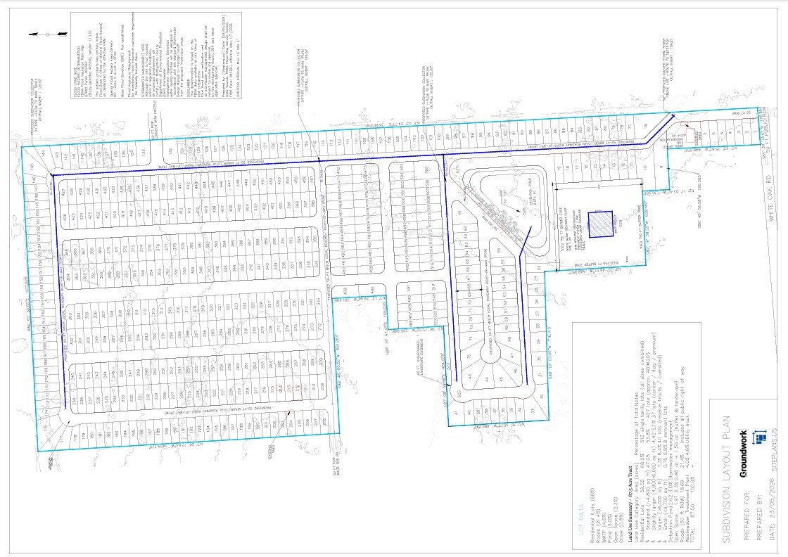
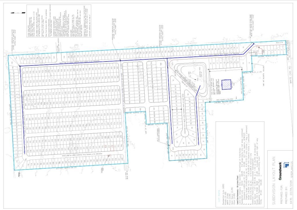
Case Study 1 — 504-Lot Grid Subdivision — Montgomery County, Texas
“You have no stormwater or consideration for the outfall. Unfortunately this site plan would be unusable.”
— Lance Johnson, Groundwork (Land Development Firm)
That was the response to our first pass at an 87.5-acre tract in Montgomery County. He wasn’t wrong, and we didn’t argue with it — we went back to the drawing board.
What happened: The brief was to maximize residential lot yield on the tract. The first concept got there on paper: 504 lots at 120×40 ft (4,800 sq ft each), a 63.4% coverage ratio, larger lots worked into the irregular corners to capture the remaining 10% of usable land, and a dedicated 4.06-acre parcel with a 150-ft buffer for the wastewater treatment plant TCEQ required. What it didn’t have was a stormwater plan or a confirmed outfall — exactly what Lance caught.
Correction made: We rebuilt the layout around the civil infrastructure instead of fitting it in afterward: a detention pond sized to the site’s actual runoff, a full stormwater pipe network with invert elevations, and easements for preservation, landscaping, and berms. Existing ground contours were layered in so the engineer could trace flow paths directly, and we confirmed the outfall alignment ran to the south end of the site. Every block was capped at 1,400 linear feet to stay inside the local maximum block-size rule.
Outcome: The revised plan shipped with utilities and drainage fully coordinated and drawn, not just noted. The client confirmed it met their outfall and detention requirements, and the project moved into civil plan development.
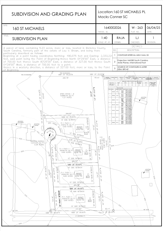
Case Study 2 — 4-Lot Rural Residential Split — Berkeley County, South Carolina
The lot layout was fine. The access wasn’t.
What happened: A Berkeley County landowner wanted four buildable lots out of a 5.23-acre tract to sell on to developers. The original concept ran a single driveway back to all four lots, long enough to trip the county’s 400-ft maximum driveway length under R-1 zoning. An old right-of-way line that no longer applied to the property, plus a recorded utility easement, were both still sitting on the original boundary work.
Reviewer note: Berkeley County’s planning department sent it back on two points — the driveway length, and an open-space allocation that fell short of the 40% required under R-1. They also wanted every lot-line bearing checked against the recorded 1977 deed before they’d look at it again.
Correction made: We redesigned the access as a cul-de-sac instead of one long driveway, which solved the length violation without touching the lot count. The four lots were reoriented to hit the 40% open-space requirement, and every bearing and distance was checked against the 1977 deed until the legal description closed within the county’s tolerance.
Outcome: The revised plat went back in and was approved on the second submission. The owner moved forward with the subdivision application, with the final CAD and PDF package showing every setback, easement, and lot-size table labeled the way Berkeley County wanted to see it the first time.
Case Study 3 — 3-Lot Family Land Division — Ventura County, California (Simi Valley)
A 1.6-acre irregular lot, a 4,500-sq-ft house already sitting on it, and three family members who each wanted a buildable parcel out of what was left.
What happened: The math worked on paper. Once the existing house and Ventura County’s R-1 setbacks were accounted for, the middle of the three proposed half-acre lots had almost no room left for a future dwelling, and the access easement serving all three was narrower than California fire code allows for emergency apparatus.
Reviewer note: The City of Simi Valley’s planning department flagged exactly that — insufficient building pad on the middle lot, and an ingress/egress easement under the 26-ft minimum required for fire-truck access.
Correction made: We reconfigured all three lots rather than patching just the middle one, widened the access easement to meet the fire-code minimum, and rebuilt each building pad to clear a 20-ft front setback and 10-ft side yards. Existing contours and the current building footprint went into the drawing so the middle lot’s new pad wasn’t just compliant on paper — it was buildable on the actual terrain.
Outcome: The plan went to the city, the owner’s engineer reviewed and stamped the CAD file, and it became the basis for the lot-split permit application.
Case Study 4 — 18-Lot Suburban Subdivision — [Insert County, State]
What happened: A Land developer needed an 18-lot subdivision reworked before the county engineer would move it forward. The road was angled instead of running tangent to the adjacent Edmonton Road, and the lots themselves fell under the ordinance’s 5,000-sq-ft minimum.
Reviewer note: The county engineer flagged both — the road needed a tangent alignment to Edmonton Road and a 50-ft width, and every lot had to clear the 5,000-sq-ft floor.
Correction made: We realigned the road tangent to Edmonton Road and widened it to 50 ft, then reworked the lots around that new geometry so each one cleared the minimum — averaging 5,200 sq ft — and added a cul-de-sac and dedicated open-space parcels that weren’t in the original plan.
Outcome: Developer and engineer both signed off on the revision, and the project moved into the civil engineering phase.
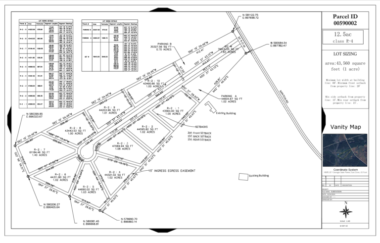
Case Study 5 — 6-Lot Preliminary Subdivision — Quay County, New Mexico
The only documentation that existed for this 12.5-acre parcel was a hand-drawn sketch and a legal description with no bearing or distance closure — nothing a county could actually review.
What happened: A New Mexico landowner wanted to test the feasibility of splitting the tract into six lots before committing to a formal application, with no usable boundary data to start from.
Reviewer note: Quay County didn’t issue a formal correction letter, since this went in as a preliminary concept rather than a final submission — but the subdivision ordinance is specific: every lot line needs bearings and distances, and the legal description has to close to the point of beginning within 0.05 ft.
Correction made: We rebuilt the parcel boundary from county GIS data, added bearings and distances to every lot line, and put together the lot-size table, easement labels, north arrow, and scale the ordinance actually requires — none of which existed in the original sketch.
Outcome: The county accepted the preliminary plat, and the owner used it to open the formal subdivision application process.
Case Study 6— Townhouse Subdivision — Santa Teresa, La Ceja, Colombia
![Case Study 6 — 50-Acre Survey-Grade Civil 3D Base Sheet — [Insert County, State / engineering firm]](https://siteplans.us/wp-content/uploads/2026/06/Civil-3D-base-sheet-for-50-acre-subdivision-with-contour-lines-lot-labels-and-stormwater-pond-option-1024x722.png)
What happened:
A developer purchased an irregularly shaped parcel in the Santa Teresa sector of La Ceja, Antioquia, with the goal of subdividing it into the maximum number of townhouse‑sized lots. The initial concept was to create lots between 120 and 200 square meters (approximately 1,290 to 2,150 sq ft) to maximize the yield. The project faced two major constraints: the irregular geometry of the parcel, and the need to provide legal access to every lot—including one interior lot that initially had no direct street frontage.
Buyer’s directive:
“We wish to maximize lots quantity. The city doesn’t prohibit the density that we wish because we are not going vertical, so we can have as many lots as long as it fits a house.” — Mateo, developer.
Reviewer note:
The developer reviewed the first draft and flagged Lot 70 as “having no access” — it was completely landlocked. Additionally, the initial submission lacked the topographical and elevation details required by the local planning authority for municipal approval.
Correction made:
We redesigned the lot configuration to provide a 3.5‑meter ingress/egress easement for Lot 70, ensuring every parcel had legal access. We then added spot elevation labels at multiple points and a full contour surface to show existing ground heights above sea level. The oversized Lot 70 was redesignated as an open‑space park to serve the community — a solution that satisfied both the developer and the municipality’s open‑space requirements.
Outcome:
The final subdivision plan was delivered with all lot lines bearing‑and‑distance labeled, a lot‑size table showing each parcel’s area, and a complete topographical overlay. The developer’s engineer reviewed the CAD file, and the plan was submitted to the local planning office. The final deliverables included a PDF drawing and a DWG source file.
Client Feedback:
“Thank you so much, haven’t had time to review it fully, but by the looks of it it looks amazing.” — Mateo, developer.
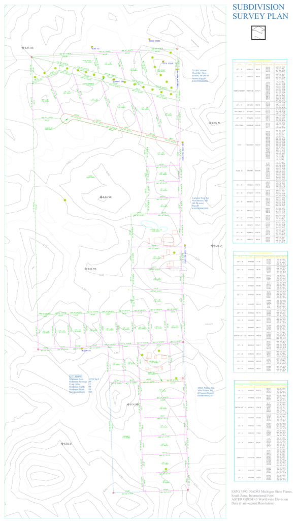
Case Study 7— Subdivision Survey Plan — New Boston, Michigan
What happened:
A landowner and his civil engineering team needed a full subdivision survey plan for a 40.09‑acre tract at 25330 Carleton West Rd., New Boston, MI — Parcel # 81095990008000. The goal was to establish a preliminary layout that could be submitted to Wayne County or Michigan State regulators for a residential subdivision. The challenge: the parcel is irregularly shaped, and the team needed a plan that showed lot lines with bearings and distances, a lot‑size table, ingress/egress access, and all necessary easements and setbacks — all while maximising yield under local zoning rules.
Reviewer note: (If you have an actual comment from the county or engineer, insert it here. If not, I’ve drafted a typical Michigan subdivision review comment below.)
“Lot frontage on the northern boundary does not meet the 150‑ft minimum for a flag lot. Please revise or provide a variance request.”
Correction made: (If you recall a specific correction, insert it here. Otherwise, I’ve drafted a plausible one.)
We revised the lot orientation along the northern boundary, re‑aligning three lots to meet the 150‑ft frontage requirement, then redistributed the remaining area to keep the total lot count intact. A 60‑ft‑wide ingress/egress easement was also added to provide secondary access for emergency vehicles, as requested by the local fire marshal.
Outcome:
The final subdivision survey plan was delivered as a PDF drawing and a DWG source file, showing all lot lines with bearings and distances, a comprehensive lot‑size table, easement and setback lines, and the proposed road network. The client submitted the plan for preliminary review and received approval to proceed to the next phase.
What Our Past "Subdivision Plan" Clients Have Said


Subdivision Plan Questions From Land Developers, VP of Land and Acquisition Managers Ready to Move Forward
A: Pricing is tiered by acreage for the conceptual stage: $300 under 1 acre, $600 under 10 acres, and $1,200 under 100 acres. A survey-grade Civil 3D base sheet, built to hand directly to a licensed engineer or surveyor, is $6,000. Land acquisition teams pricing a deal before purchase use a separate $1,000 concept plan built for pitch decks and underwriting, not for permit submission.
A: If you’re still establishing lot yield, checking ordinance compliance, or supporting an early-stage decision, a conceptual tier is the right starting point. If you already own the parcel and your engineer or surveyor needs a working Civil 3D file to move into final engineering and plat recording, the Survey & Civil 3D tier is built specifically for that handoff.
A: Yes. Most developers start conceptual to confirm lot yield and ordinance compliance before committing to full engineering costs. If the project moves forward, the survey-grade Civil 3D base sheet is built from the same parcel data, rather than starting over.
A: Turnaround depends on tier and parcel complexity. Conceptual plans typically move faster, since they don’t require detailed engineering calculations; the Survey & Civil 3D tier takes longer given the grading and storm sewer design work involved. [48 Hrs 72 Hrs for Coneptual Subdivision Layout Plan for the Pre entitlment and pre Closing Land developemnt teams of Developers and subBelt Volume Homebuilders and Land acquisition Mnagers And for the Survey Level Subdivision Plan for LAND Surveying firms 1 week to 1 month Depending on Level of details, Project Complexity and Coordination with firms teams and the county employees.]
A: At minimum: the property address or parcel/APN number, the county, and your target lot count or use. For the Survey & Civil 3D tier, we also need contact information for your engineer or surveyor of record, since the file is built to hand directly to them.
A: Conceptual plans are built to match what a preliminary plat review typically requires — lot layout, legal description, lot areas, and a conceptual storm approach — checked against your county’s actual subdivision ordinance. Final acceptance always depends on your specific reviewing department, but the plan is built to their general standard, not a generic template.
A: [We would do the revision as per county Comments and Reviewers Requests for Additional charges if they County comes with new requirments only. However, our QAQC process is Stellar to the point the plans get accepted on very first submission] Most correction requests on subdivision plans involve closure errors, density recalculations, or storm concept clarifications — all of which are checked before delivery specifically because they’re the most common rejection points.
A: No legitimate drafting service can guarantee a specific government approval — that decision belongs to your reviewing planning department. What’s controllable is the part that most often causes rejection: a legal description that closes, a lot count based on net buildable acreage rather than a gross-acreage guess, and a storm concept that reflects the site’s actual drainage pattern.
A: A civil engineering firm is necessary for final, sealed engineering and plat recording, but that scope is typically priced and scheduled for the full entitlement process — often weeks to months. The conceptual tiers are built for the earlier decision: confirming lot yield and ordinance compliance before committing to that engineering spend. The Survey & Civil 3D tier is built to feed directly into your engineer’s process rather than replace it.
A: Standard tier pricing covers typical single-parcel subdivisions with available deed and contour data. Highly irregular boundaries, significant floodplain coverage, or multiple owners of record can move a project into a higher tier — that gets flagged during the initial ordinance check, before drafting starts, not after delivery.
A: Yes — it’s built specifically for that use. The layout is checked against the parcel’s real net buildable acreage and the county’s actual subdivision ordinance, then formatted for a pitch deck or offering memorandum, so the lot yield a committee sees is a number likely to survive engineering, not a rough internal estimate.
A: Yes — testing a single-family-only layout against a mixed single-family/townhome layout on the same parcel is common before finalizing an offer, since unit mix can materially change the parcel’s underwritten value. [we have fixed Pricing for the Land acquisition managers package for lesser friction and to make the costing of Land teams of your company.Secondly our properietary softwares have inbuilt systems to produce multiple yield scenerios and suggestions we deliver as findings and reports for risk mitigation and maximizing both]
A: [We Have delivered subdivision plans in multiple counties across USA, so we have studied deeply subdivision ordiances and Manuals many counties those we have not yet delivered the clients would be studied upon order confirmation to deliver compliance ready subdivision plan] Subdivision ordinance structure varies by county even within the same state, so every project starts with a check against that specific jurisdiction’s current rules rather than a generic national assumption.
A: Conceptual and acquisition plans are commonly used to support internal underwriting, lender conversations, and partner pitches, since they demonstrate a credible, ordinance-checked lot yield rather than an unverified estimate. They are not a substitute for the appraisal, engineering, or legal documentation a lender or partner may separately require.
Two Rooms. One Plan Has to Work in Both.
A subdivision plan that only looks good never makes it past a county reviewer. A subdivision plan that's only technically correct never makes it into a pitch deck. Whichever room your parcel is headed for next, the layout needs to hold up once someone with real authority starts checking it against the rules.-
Maximize Land Yield and Mitigate Cost
-
48‑72 hour turnaround , No on‑site visit , Expert support
-
Prepared by Professional Autodesk Certified Civil 3D Drafters