Home » Home » Florida Site Plans » Jacksonville Site Plan
Jacksonville Site Plan – $89, 24-Hour Turnaround, Built to Clear JaxEPICS Review
Your BFE was missing. Your grand tree wasn't located. Your lot coverage math was wrong. That's why Jacksonville sent it back.
The correction letter arrived three weeks after submission. One line read: “Finished floor elevation not shown relative to Base Flood Elevation. FEMA flood zone designation required.” Another: “Grand tree (24″+ DBH) not identified. Tree protection plan absent.”
The contractor already had a start date. The lumber was ordered. That date moved.
Jacksonville’s Building Inspection Division doesn’t flag things arbitrarily. Every comment in a “Return for Corrections” notice points to a real checklist item — and every resubmission goes back into a 10-business-day queue. When a plan goes in missing BFE notes, wetland buffers, or a properly calculated impervious surface figure, that queue starts over.
We draft plans that go in complete. Not approximate. Not close enough. Complete.
Enter your address. We pull Duval County parcel records, verify your flood zone and Base Flood Elevation, identify protected trees, check your zoning district setbacks under Ordinance Code Chapter 656, and deliver a PDF built for BID sign-off.
- 24-hour delivery for most residential projects
- Free revisions if the city returns corrections
- $89–$249 fixed pricing
Why Jacksonville Plans Fail the First Time
Jacksonville operates a consolidated city-county government through Duval County. That means one permit office — the Building Inspection Division — reviews plans for the entire county. Before BID even touches your application, it routes through the Development Services Division (Zoning, Drainage, DMG), the Fire Marshal if triggered, and potentially FEMA/Flood and Historic review agencies.
Each of those reviewers can independently place your file in Return for Corrections status. BID doesn’t start its review until every upstream agency clears the application. One missing note in the zoning section adds weeks before the structural review begins.
The most common reasons Jacksonville residential permits return for corrections:
1. Finished floor elevation not shown relative to BFE Jacksonville sits in one of Florida’s most flood-active counties. AE zones cover large portions of the city — along the St. Johns River, Ortega River, Ribault River, and their tributaries. The Florida Building Code requires new construction to be elevated at least 1 foot above Base Flood Elevation. If your plan doesn’t show the flood zone designation, the FEMA panel number, the BFE, and the proposed finished floor elevation — it comes back before BID opens the file.
2. Grand tree not located, no tree protection plan Jacksonville’s tree ordinance (Ordinance Code Chapter 656, Part 12) creates three tiers of protection. Grand trees — any species at 24 inches DBH or more — require a Planning Commission variance for removal and must be shown on the site plan with drip-line protection barriers. Specimen trees at 12″+ DBH require 1:1 caliper-inch mitigation. Heritage species like live oak and magnolia trigger additional review at 18″+ DBH. A plan that doesn’t show these trees doesn’t pass the Zoning section of DSD review.
3. Impervious surface calculation absent or wrong Jacksonville’s stormwater regulations tie to the SJRWMD (St. Johns River Water Management District). Projects that create more than 4,000 square feet of impervious surface or disturb more than an acre may trigger an Environmental Resource Permit. Even below that threshold, your site plan needs to show the impervious surface tally — house footprint, driveway, walkways, patio — and demonstrate it doesn’t exceed the zoning district’s lot coverage limits.
4. Setbacks measured to foundation rather than to the furthest projection Florida Building Code measures setbacks to the most-projected building element — eave, overhang, gutter, or cantilevered floor. Plans that measure to the foundation edge get redlined at BID. In RLD-60 zoning (the most common Jacksonville residential district), front setbacks are 25 feet, rear 20 feet, sides 7.5 feet — all measured correctly.
5. Wetland boundary absent or undifferentiated from uplands Jacksonville has extensive wetland coverage across its 875 square miles. If your parcel borders a jurisdictional wetland, the site plan must show the delineated wetland boundary and the proposed buffer. Without it, the application triggers SJRWMD and Army Corps review flags that can add months.
6. ADU exceeds 25% of primary structure or 750 square feet Jacksonville caps detached ADUs at the lesser of 750 square feet or 25% of the primary structure’s square footage. ADUs also cannot exceed the height of the primary residence. Plans submitted without these calculations verified get returned before the first structural review.
What Your Jacksonville Site Plan Includes
| What We Provide | Why It Matters to Jacksonville Reviewers |
|---|---|
| Property lines from Duval County recorded plats | GIS coordinates have rounding error. Legal plat dimensions are what reviewers compare against. |
| Flood zone, FEMA panel number, BFE, proposed FFE | Required before DSD Drainage and FEMA/Flood agency reviews can clear. |
| Setbacks measured to furthest projection | Foundation measurement is an automatic redline. We measure to the eave or overhang. |
| Grand tree locations with drip lines | Zoning reviewers check aerials. Trees over 24″ DBH must appear on the plan with protection zones noted. |
| Specimen tree notation (12″+ DBH) | Required mitigation calculation must be indicated when applicable. |
| Impervious surface calculation | Lot coverage math for RLD-60 and other residential districts — structure, driveway, hardscape totaled. |
| Wetland boundary (when applicable) | Required by SJRWMD before DSD Drainage review completes. We flag proximity and show the boundary. |
| ADU size, height, lot coverage verification | 750 sq ft cap or 25% of primary — we verify before you submit. |
| JEA utility connection points | Water, sewer, and electric connection locations shown — JEA coordination is separate, but the plan must reflect connections. |
| North arrow, engineering scale, legal description | Missing any of these means rejection before substantive review begins. |
| Driveway width and access geometry | Minimum widths and turning geometry per Jacksonville’s access standards. |
What Real Jacksonville Correction Letters Say
These are the kinds of comments that appear in JaxEPICS Return for Corrections notices on residential plans:
“Flood zone designation and FEMA panel number not provided. Base Flood Elevation and proposed finished floor elevation must be shown on the site plan.”
We add the flood zone, panel number, BFE, and FFE to every plan in a flood-mapped area. Even in Zone X, the designation needs to appear.
“Grand tree (DBH 26″) identified on aerial but not shown on site plan. Tree protection zone required per Ordinance Code §656.1204.”
We locate grand trees, show their drip lines, and add the required tree protection barrier notation. Jacksonville reviewers cross-reference aerials. We draw what they’ll be looking at.
“Impervious surface coverage not calculated. Site in RLD-60 district — lot coverage maximum applies. Calculation required.”
We run the arithmetic: structure footprint, driveway, patio, and walkway areas totaled and expressed as a percentage of lot area. Every time.
“Setback dimensions shown to foundation. Measurement must be to furthest projection. Resubmit with corrected dimensions.”
Foundation measurements fail in Jacksonville just as they fail everywhere in Florida. We measure from the eave — or from whatever is furthest out.
“Wetland delineation boundary not shown. Property located within 50 feet of jurisdictional wetland per SJRWMD maps. Boundary required before DSD Drainage review can be completed.”
If your parcel is near a jurisdictional wetland, we flag it early and show the boundary. Missing this doesn’t just delay — it stops DSD review entirely until resolved.
“ADU square footage exceeds 25% of primary structure. Proposed 850 sq ft ADU on 2,900 sq ft primary home limited to 725 sq ft. Revise footprint.”
We calculate the cap before you order. 750 sq ft hard limit, or 25% of the main house — whichever is smaller.
Get a Plan That's Ready for All of Jacksonville's Reviewers
Pricing — What You Get at Each Level
| Service | Price |
|---|---|
| Basic Site Plan — property lines, existing/proposed structures, setbacks, scale, north arrow | $89 |
| Enhanced Plan — adds flood zone + BFE + FFE, impervious surface calculation, tree locations, easements, utilities | $149 |
| Premium Plan — adds ADU compliance verification, wetland boundary, complex lot geometry, grading notes | $249+ |
✅ Free revisions if Jacksonville returns a correction letter
✅ 24-hour turnaround on most residential projects
✅ No survey required for the majority of single-family projects
Real Jacksonville Case Study – ADU Returned Twice, Cleared on Third
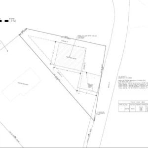
Detached ADU, Westside neighborhood (RLD-60 zoning)
A plan from a national template service. It had a footprint, some setback dimensions, and a north arrow.
“Flood zone not identified. FEMA panel number required. BFE not shown. Proposed FFE not shown. Grand tree (estimated 28″ DBH based on aerial review) not located on plan. Tree protection plan absent. Impervious surface calculation not provided.”
They added a flood zone label (“AE”) but no panel number and no BFE figure. They drew a circle near where they thought the tree was. No drip line, no protection barrier notation.
“FEMA panel number still missing. BFE value required — ‘AE’ designation alone insufficient. Tree location approximate — certified survey or arborist location required. Tree protection barriers not shown. Impervious surface calculation still absent.”
- Added FEMA Flood Map Panel 12031C0290J (the correct panel for that parcel area), with BFE 7.5 NAVD88, and a proposed FFE of 8.5 NAVD88.
- Located the grand live oak at 29″ DBH with the full drip-line radius and protection barrier call-out per §656.1204.
- Ran the impervious surface calculation: 1,680 sq ft structure + 480 sq ft driveway + 120 sq ft walkway = 2,280 sq ft total on a 9,400 sq ft lot = 24.3% coverage (within RLD-60 limits).
- Verified ADU at 748 sq ft (within the 750/25% cap on the 3,100 sq ft primary structure).
Cleared DSD review on the next submission cycle. BID issued the permit 12 business days later. Total time lost on the first two attempts: 11 weeks.
Why Jacksonville Projects Carry Extra Risk Without the Right Plan
Jacksonville is the largest city by land area in the contiguous United States. That size brings real variability: soil conditions differ between the Westside and Arlington; flood exposure is more acute near the St. Johns River than inland; the Northside and Southside have different grand tree densities; historic districts in Springfield or Riverside require design review that most of the city doesn’t.
A plan drafted without knowing which of Jacksonville’s 875 square miles your parcel sits in is a plan that will likely come back.
The JaxEPICS portal routes your application to multiple concurrent reviewers. If DSD flags a wetland issue, BID doesn’t begin its review. If the FEMA/Flood agency flags a missing BFE, nothing moves downstream. A plan with all those items addressed from the start doesn’t wait in sub-queues.
We build Jacksonville plans starting from what those queues will check — not from a blank canvas.
Why Homeowners Buy Site Plans from Us
24‑hour turnaround – Most plans delivered tomorrow.
Fixed pricing – $89–$249, no hourly surprises.
Free revisions – If Jacksonville City asks for changes, we revise at no cost.
Permit‑focused drafting – We start with San Diego’s submittal checklist, not a blank screen.
Coastal and flood ready – We add required notes so you don’t get a correction letter.
ADU‑ready – We verify size, height, parking, and lot coverage before you order.
No survey needed for most projects – We use recorded plats and county GIS.
FAQs — Jacksonville Homeowners Ask These
Almost certainly yes. Properties in AE flood zones — which cover much of the land adjacent to the St. Johns, Ortega, and Ribault Rivers — require the FEMA flood zone designation, panel number, Base Flood Elevation, and proposed finished floor elevation on the site plan before DSD Drainage review will clear. We add all of it.
If it’s a live oak or another heritage species at 18″+ DBH, or any species at 24″+ DBH, Jacksonville’s tree ordinance requires it to be located on your site plan with a drip-line protection zone. If you’re proposing to remove it, you’ll need a Planning Commission variance — that’s a separate process. We show the tree correctly so the plan clears Zoning review.
Initial review for a building permit averages 25–30 business days per BID’s current timeline. Resubmissions after corrections review in 10 business days or less. Each correction cycle adds weeks. A complete first submission avoids that entirely.
Not for most projects. We use recorded plats and county GIS. If your property has a boundary dispute, we may recommend one.
Yes. Jacksonville caps detached ADUs at the lesser of 750 square feet or 25% of the primary structure’s square footage. ADU height cannot exceed the primary residence. We calculate both figures before finalizing the plan. If your property is in a historic district like Springfield or Riverside, there are additional design standards — we flag those too.
Not necessarily. For many standard residential lots, there’s no wetland trigger. If your parcel is near a known wetland area on SJRWMD maps, we’ll flag it in the planning stage and advise whether a formal delineation is needed before submission. We don’t hide complications — we surface them early.
PDF format is required for all uploads through the JaxEPICS portal. Plans must be to scale with a scale bar shown, include a north arrow, and provide a legal description. We deliver in PDF at the correct engineering scale with all required title block elements.
Official Jacksonville Permit Resources
- Jacksonville Building Inspection Division (BID) — 214 N. Hogan Street, Jacksonville, FL 32202. Phone: (904) 255-8500, Monday–Friday 7 a.m.–4 p.m.
- JaxEPICS Permit Portal — All residential permits submitted electronically: jaxepics.coj.net
- Jacksonville Zoning Code (Ordinance Code Chapter 656) — Setbacks, ADU rules, lot coverage, tree protection (Part 12).
- Jacksonville Tree Mitigation System — Tree removal permit records and mitigation tracking: jaxtreemitigation.coj.net
- St. Johns River Water Management District (SJRWMD) — Environmental Resource Permits and wetland delineation: sjrwmd.com
- FEMA Flood Map Service Center — Flood zone and BFE lookups by address: msc.fema.gov
- Duval County Property Appraiser — Parcel records, legal descriptions, and plat data: dcpafl.org
Other Florida Cities We have Served
SitePlans.us drafts permit-ready plans across Florida and all 50 states — delivered online, no site visit needed.
Tampa | Orlando | Miami | Fort Lauderdale | St. Petersburg | Tallahassee | Gainesville | Pensacola | Sarasota | Fort Myers | Naples
Also serving: Phoenix | Atlanta | Charlotte | Nashville | Austin | Dallas | Houston | Denver | Seattle | Portland | Las Vegas | Sacramento
Don’t see your city? We work in all 50 states. Enter your address at checkout.
Other cities we’ve helped (Sunbelt States):
Phoenix | Tucson | Las Vegas | Denver | Colorado Springs | Austin | Dallas | Houston | Fort Worth | Atlanta | Savannah | Portland | Seattle | Charlotte | Raleigh | Nashville | Orlando | Jacksonville | Tampa | Miami
Don’t see your city? We cover all 50 states. Just enter your address at checkout.
98% First‑Time Approval. You Read That Right.
Most homeowners wait weeks for a rejection. Our plans are built to pass on the first submission – because we already know what reviewers flag.
Upload Your Address at 9 AM. Get a Reviewer‑Ready Plan by Tomorrow.
Stop Researching. Start Uploading. We’ll Handle the Rest.
Your Contractor Is Waiting. Don’t Let a Missing Note Cost You 4 Weeks.
One missing setback or easement reference pushes your permit to the back of the queue. We catch it before you submit.
Platinum Site Plan
Highest Acceptance Rate for New Homes, Commercial & Complex Projects- Highest acceptance rate
- 24‑hour turnaround , No on‑site visit , Expert support
- Prepared by Professional Autodesk Certified Civil 3D Drafters
- Site Plan Packages
Platinum Site Plan
$380.00Original price was: $380.00.$250.00Current price is: $250.00. Select options - Site Plan Packages
Gold Site Plan
$200.00Original price was: $200.00.$159.00Current price is: $159.00. Select options - Site Plan Packages
Standard Site Plan
$160.00Original price was: $160.00.$119.00Current price is: $119.00. Select options - Site Plan Packages
Basic Site Plan
$100.00Original price was: $100.00.$89.00Current price is: $89.00. Select options