
Home » Residential Site Plans » Home Addition Site Plan
Your Addition Is Designed. Your Contractor Is Priced. Now the Building Department Wants a Site Plan.
You didn't spend three months picking a floor plan and getting bids just to lose six weeks in a permit queue because the site plan showed the setback to the foundation instead of the eave.
That’s the part nobody warns you about. The addition itself isn’t the problem. The paperwork that has to describe it — accurately, completely, in the format your specific city’s reviewer expects — is where projects stall.
Addition permits fail at the site plan stage for reasons that have nothing to do with the design. The proposed footprint pushes lot coverage over the district maximum when the driveway is included in the math. The existing nonconforming setback on the original house isn’t documented, so the reviewer can’t tell whether the addition maintains or worsens the nonconformity. The flood zone notation is absent on a parcel that sits 300 feet from a regulated creek.
These aren’t design problems. They’re documentation problems — and documentation problems have a 24-hour fix.
Enter your address and tell us what you’re adding. We pull your parcel records, verify your zoning district, check your existing setbacks, calculate the combined lot coverage, flag any nonconformity issues, and deliver a PDF your building department can approve without sending back.
$89 for standard additions. $249 for complex lots, flood zones, or nonconforming structures. Delivered tomorrow. Free revisions if corrections come back.
The Part of Addition Permits That Catches Homeowners Off Guard
Most homeowners expect the hard part of an addition permit to be the structural drawings — the engineered plans showing beam sizes, foundation details, and load calculations. Those are complex documents. But they’re prepared by architects and engineers who know exactly what’s required.
The site plan is the document that gets treated as an afterthought. It’s “just a drawing showing where the addition goes.” How hard can it be?
Hard enough that a significant percentage of addition permit applications come back for corrections on the site plan specifically — not on the structural drawings, not on the electrical plans, but on the overhead view of the property that was supposed to be the simple part.
Here’s why addition site plans generate more correction comments than homeowners expect:
Nonconforming structures are a trap. Thousands of homes across the US were built before modern zoning codes were adopted. A house built in 1962 with a 12-foot front setback in a district that now requires 25 feet is legally nonconforming — it was built legally and is allowed to remain, but it can’t be made more nonconforming. If your addition extends toward a property line that the existing house already doesn’t fully comply with, the reviewer needs to see the nonconformity documented and the addition verified as not worsening it. Plans that don’t address this produce comments that require more than a simple revision.
Lot coverage math gets complicated on older lots. The house was built in 1978. A deck was added in 1989. A storage shed appeared sometime in the 1990s. The driveway was widened in 2003. None of those previous additions were tallied against a lot coverage maximum at the time — but the addition permit application requires the current total. Reviewers calculate it. If your plan doesn’t show it accurately, you’ll get a comment asking you to.
The addition changes the setback picture for the whole structure. Even when the addition itself clears all required setbacks, extending the building footprint means re-verifying setbacks from every affected property line. A rear addition that adds 20 feet to the back of the house changes the rear setback calculation for the entire structure, not just the new portion. Plans that show the addition footprint without re-documenting all affected setbacks come back.
Second-story additions have height implications. In zoning districts with maximum building height limits — which covers most residential districts in US cities — a second-story addition or a raised roofline needs the new height documented on the plan and verified against the district maximum. Plans that add a second floor without noting the resulting height produce a comment before structural review opens.
What Real Addition Permit Correction Letters tells you
“Existing nonconforming setback not documented. Proposed addition must not increase nonconformity. Provide existing setback dimensions for entire structure before and after addition. Resubmit.”
We document the existing structure’s setbacks completely — including any nonconformities — and show how the addition maintains or improves compliance. Reviewers can’t evaluate nonconformity without a complete picture of what’s already there.
“Lot coverage calculation incomplete. Existing deck, shed, and driveway not included. Maximum lot coverage for R-2 district is 35%. Submit complete impervious surface tally including all existing and proposed structures and hardscape.”
We calculate every square foot of hardscape on the parcel — the house, the addition, the driveway, the patio, the shed, the deck — and express it as a percentage of the total lot area. Every time.
“Proposed addition setback from rear property line not shown. Dimensions required from all property lines to proposed structure including eave overhang. Resubmit.”
Every affected setback gets labeled on the plan. We measure to the furthest projection — eave, overhang, or cantilevered floor — not to the foundation wall.
“Flood zone notation absent. Property located within 500 feet of regulated waterway per FEMA mapping. Zone AE designation and Base Flood Elevation required on plan prior to review.”
We check FEMA flood mapping for every parcel. A property near a creek, drainage channel, or river tributary that sits in an AE zone needs the designation, panel number, and BFE on the plan before the application moves forward.
“Second floor addition shown without height notation. Maximum building height in this district is 35 feet. Provide existing and proposed building height measured from average grade to highest point of roof. Resubmit.”
We add height notation to every plan involving a vertical addition. Measured from the correct reference point for your jurisdiction — typically average grade, sometimes natural grade, sometimes finished floor depending on the city.
“Site plan does not reflect current parcel configuration. County records show a lot line adjustment recorded in 2019 that is not reflected on submitted plan. Resubmit with current legal boundaries.”
We pull parcel dimensions from county recorder records — not from GIS data, which may not reflect recent lot line adjustments, easements recorded after subdivision, or boundary corrections. What we draw matches what’s on file.
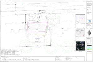
What Every Addition Site Plan We Deliver Includes
| Plan Element | What It Resolves |
|---|---|
| Existing structure footprint — complete | Full documentation of what’s already on the parcel, including any nonconforming setbacks |
| Proposed addition footprint with dimensions | Scaled accurately; all sides dimensioned |
| All setbacks re-verified post-addition | Every affected property line distance shown to furthest projection |
| Nonconformity documentation | Existing nonconforming conditions noted; addition verified as not worsening them |
| Complete lot coverage calculation | House + addition + all existing hardscape expressed as % of lot area |
| Building height notation | Existing and proposed height verified against district maximum where applicable |
| Flood zone + FEMA panel number | Added for all parcels in or near flood-mapped areas |
| Tree protection zones | Protected trees within disturbance area shown with dripline notation |
| Easements with instrument references | County recorder book and page; easement setback clearances shown |
| Property lines from recorded plat | Legal dimensions — not GIS coordinates. Reflects any recorded lot line adjustments. |
| North arrow, engineering scale, legal description | Required on every submittal; missing any produces rejection before review begins |
| Utility connections | Existing service connections shown; any new connections noted |
Addition Types We Draft Site Plans For
Rear addition — The most common configuration. Extends the house footprint toward the rear property line. Rear setback re-verified for the full structure post-addition. Lot coverage calculated with addition included.
Side addition — Extends toward a side property line. Side yard setbacks are often the tightest on residential lots — 5 to 7.5 feet in most districts. Eave overhang on a side addition frequently brings the structure closer to the property line than the foundation suggests. We measure to the eave.
Second story addition — Doesn’t change the footprint but adds building height. Height verification against district maximum required. In some cities, a second story triggers design review in historic districts or requires an updated impervious surface calculation if any exterior modifications accompany it.
Garage conversion to living space — The garage disappears from the footprint as a garage and becomes part of the primary structure. Lot coverage may decrease if the driveway is removed, or stay the same if it isn’t. ADU review may be triggered depending on how the converted space is used. We verify which standard applies before the plan is drawn.
Sunroom or enclosed porch — Treated as an addition to the primary structure in most jurisdictions. Setback and lot coverage implications are the same as any other addition. Roofed and walled structures are measured the same way regardless of how they’re used.
Master suite or bedroom addition — Structurally the same as a rear or side addition from the permit perspective. The use of the space doesn’t change the site plan requirements — the footprint, setbacks, and coverage math are what the reviewer checks.
Addition Permits in Cities We Know Well
Sacramento, CA — Tree ordinance (Chapter 12.32) applies to any ground disturbance near protected species. Impervious surface calculation required. Setbacks measured to eave. Nonconforming structures documented before addition is reviewed against them.
Jacksonville, FL — BFE required on plan for AE zone parcels before BID review opens. Grand tree (24″+ DBH) must appear on plan if within disturbance area. Lot coverage tracked against RLD-60 or applicable district maximum.
Raleigh, NC — Impervious surface itemized line by line — addition square footage listed separately. Pre-May 2001 lots use grandfathered stormwater framework. Neuse River buffer shown if USGS blueline stream present on parcel.
Austin, TX — Impervious cover limit tied to watershed zone — a rear addition on a lot near its impervious cap may require a stormwater review. Heritage tree root zone check required before any ground disturbance within 50 feet of a 19″+ DBH tree.
Dallas, TX — Lot coverage and impervious surface tracked as separate figures. Nonconforming structure documentation required. Easements from Dallas County deed records.
Phoenix, AZ — Setbacks for additions verified against current district standard, not the original construction standard. Height limits enforced strictly in hillside overlay zones.
Pricing
| Plan | Price | Best For |
|---|---|---|
| Basic – $89 | Straightforward rear or side addition on a standard lot | Existing and proposed footprints, setbacks, lot coverage, north arrow, scale, legal description |
| Enhanced – $149 | Addition with flood zone, tree coverage, or easement factors | Adds FEMA data, tree notation, easement references, impervious line items, utility connections |
| Premium – $249+ | Nonconforming structures, second-story additions, complex lots, historic overlays | Full nonconformity documentation, height verification, complete compliance review for your specific city and district |
✅ Free revisions on any correction comments
✅ 24-hour turnaround on most addition projects
✅ All 50 states — parcel-specific research every time
✅ No survey required for most addition permits
FAQs — Home Addition Site Plans
Usually yes — legally nonconforming structures are allowed to remain and in most jurisdictions can be expanded, as long as the addition doesn’t increase the nonconformity. A rear addition on a house with a nonconforming front setback is typically fine. A side addition that pushes the structure even closer to the side property line it already encroaches on is a different story. We document the existing nonconformity on the plan and show how the addition relates to it — which is exactly what the reviewer needs to see to approve it.
In most US jurisdictions, yes. Any addition that requires a building permit — which is virtually all structural additions regardless of size — requires a site plan showing its location on the property. The size of the addition doesn’t change the documentation requirement. It may affect which tier of plan you need, but not whether you need one.
Yes. Reviewers need the complete setback picture for the entire structure — not just the area being modified. A rear addition changes the rear setback calculation for the whole building. All four setback dimensions need to appear on the plan, measured correctly from every property line, to give the reviewer a complete picture of compliance.
We calculate it before the plan is finalized. If the addition pushes you over the district maximum, we’ll tell you before you submit — not after the correction letter arrives. In some cases, removing existing hardscape (a shed, a section of driveway, a patio) can offset the addition’s coverage impact. We’ll flag the situation and let you make the call.
We can prepare the site plan and flag the historic overlay requirement. Properties in locally designated historic districts — Oakwood in Raleigh, Riverside in Jacksonville, Curtis Park in Sacramento — typically require a Certificate of Appropriateness or similar approval from the historic review body before the building permit application is accepted. That’s a separate process from the site plan, but we note it on the plan so you go into the process with the full picture.
It usually means the plan was drafted from GIS data, which rounds coordinates and may not reflect recorded lot line adjustments, boundary corrections, or subdivision plat revisions. We pull dimensions directly from county recorder records — the same source the reviewer compares against. If there’s a discrepancy between the GIS data and the recorded plat, we use the recorded plat.
Other Project Types We Cover for Homeowners in US
Pool Site Plan for Permits We've Worked Across These Cities
ADU rules are local. Every order includes jurisdiction-specific research — not a static template