
Home » Site Plan for Permit
Site Plan for Permit – $89 | 24-Hour Delivery | All 50 States
Your permit application is sitting incomplete because the building department wants a site plan. We draft it today. You submit tomorrow.
No architect. No surveyor. No back-and-forth with a local drafting firm that quotes you $400 and a two-week wait.
Enter your address. We pull your parcel records, check your zoning district, verify your setbacks, add the city-specific notes your reviewer will look for, and deliver a permit-ready PDF within 24 hours.
$89. Fixed price. Free revisions if the city sends it back.
Your Building Department Has a Checklist. We Know What's On It.
A site plan gets rejected for one reason: it’s missing something the reviewer is required to flag.
Not because the project is complicated. Not because the zoning is difficult. Because the plan didn’t show the flood zone, or the setback was measured to the foundation instead of the eave, or the impervious surface calculation was a single combined number when the city wants line items.
Those aren’t hard problems. They’re knowledge problems — and they cost you the time to resubmit and wait in queue again.
We draft site plans starting from your city’s submittal checklist, not from a generic residential template. The flood note, the tree protection call-out, the easement instrument reference, the ADU size verification — those go on the plan before it leaves our desk, not after the correction letter arrives.
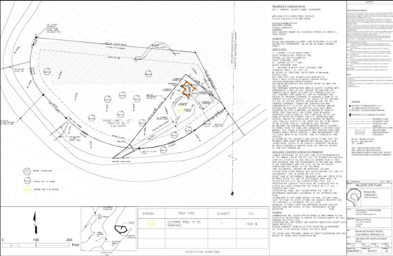
What a Permit Site Plan Must Show — And What Gets Flagged When It Doesn't
| Required Element | What Happens When It’s Missing |
|---|---|
| Property lines from recorded plat | Reviewer compares against legal documents. GIS rounding fails this check. |
| Setbacks to furthest projection | Foundation measurements get redlined in every jurisdiction. Eave, overhang, gutter — we measure to the right element. |
| Existing and proposed structures | Both must appear. “Proposed only” plans come back on the first cycle. |
| Lot coverage calculation | Most cities cap impervious surface. No calculation means automatic comment. |
| Flood zone + FEMA panel number | Required even in low-risk zones in many cities. One line, but reviewers check for it. |
| Easements with instrument references | “Utility easement” alone gets rejected. Book and page number required. |
| North arrow + engineering scale | Missing either means rejection before substantive review begins. |
| City-specific notes | Tree ordinances, riparian buffers, BFE, ADU caps — vary by city, always required. |
Every plan we deliver includes all of the above, plus the city-specific items your jurisdiction requires.
Projects That Require a Site Plan for Permit
- Detached ADU or garage apartment —
Zoning must verify lot coverage, setbacks, height, and the ADU-specific size cap for your city before the application moves forward.
- Attached or detached garage —
Setback from all property lines, lot coverage contribution, and impervious surface impact documented on the plan.
- Home addition —
Existing footprint plus proposed addition verified against current zoning district limits. Setback compliance from every boundary.
- Swimming pool —
Setbacks from property lines and structures, equipment pad location, barrier notation. Many cities also require drainage direction shown.
- Deck, patio, or covered porch —
Setbacks from property lines and structures, equipment pad location, barrier notation. Many cities also require drainage direction shown.
- Shed or accessory structure —
Even structures under 200 square feet have setback requirements in most cities. Plans required before permit issuance.
- Fence
Property line location, easement clearance, and height compliance relative to zoning district shown on plan.
- Driveway addition or expansion —
Access geometry, impervious surface impact, and right-of-way clearance documented.
If your permit application has a line that says "site plan required" — this is what fills it.
What We Need From You. What We Handle.
1
Your property address
2
Your project type (garage, ADU, pool, addition, etc.)
3
Any prior permit documents or surveys if you have them (not required)
We handle:
- Parcel research from county recorder records
- Zoning district identification and setback verification
- Flood zone and FEMA panel lookup
- Tree ordinance status check
- ADU cap verification if applicable
- Drafting to your city’s submittal format
- City-specific notes added to plan face
- PDF delivery formatted for your permit portal
You don’t touch a zoning map. You don’t call the building department. You don’t figure out what “measured to the furthest projection” means.
Pricing
| Plan | Price | Includes |
|---|---|---|
| Basic – $89 | Standard residential permits | Property lines, structures, setbacks, lot coverage, flood zone, north arrow, engineering scale, legal description |
| Enhanced – $149 | Projects with environmental or code complexity | Adds tree protection notes, riparian buffer extents, easement references, impervious line items, utility connections |
| Premium – $249+ | ADUs, additions, complex parcels | Adds ADU compliance verification, grading notes, historic overlay notation, Missing Middle project types |
✅ Free revisions on any city correction comments
✅ 24-hour delivery for standard residential projects
✅ Accepted by building departments in all 50 states
✅ No site visit, no survey required for most projects
Cities With Specific Permit Site Plan Requirements
Every US city has its own submittal checklist. These are some of the markets we know in depth — and what their reviewers specifically require:
Sacramento, CA — FEMA panel number required even in Zone X. Tree driplines under Chapter 12.32. ADU cap at 800 sq ft. Setbacks measured to eave.
Jacksonville, FL — Base Flood Elevation and proposed finished floor elevation required before BID review opens. Grand trees (24″+ DBH) must be located with drip-line protection. ADU capped at 750 sq ft or 25% of primary — whichever is smaller.
Raleigh, NC — Impervious surface must be listed as line items, not combined totals. Lots recorded before May 2001 fall under a different stormwater framework. Neuse River riparian buffer (Zone 1 + Zone 2) required on any parcel with a USGS blueline stream.
Austin, TX — Impervious cover limits tied to watershed zone. Waterfront Overlay and Critical Water Quality Zone trigger additional setback requirements. Heritage trees (19″+ DBH) require review before removal.
Dallas, TX — Lot coverage and impervious surface tracked separately. Floodplain shown on plan for properties near Trinity River tributaries. Easement references required from Dallas County deed records.
Fort Worth, TX — Floodplain shown per City of Fort Worth Flood Map. Drainage easements require recorded instrument numbers. ADU rules vary by base zoning district.
What Happens When a Site Plan Gets Rejected
The correction letter arrives. Your contractor’s schedule shifts. The lumber order gets pushed. The project that was supposed to start next week is now sitting in a resubmission queue that runs 10 to 30 business days depending on the city.
Most correction letters say the same things:
- Flood zone not identified
- Setback measured incorrectly
- Impervious surface calculation missing
- Protected tree not shown
- Easement reference incomplete
- ADU exceeds size cap
None of those require a redesign. They require a drafter who knew the checklist going in.
If you’ve already received a correction letter — send it to us. We revise the plan to address every comment, typically within 24 hours. No additional charge.
If you haven’t submitted yet — order now and avoid the queue entirely.
FAQs
In the vast majority of US jurisdictions, yes — any project that requires a building permit also requires a site plan showing where the proposed structure sits on the property relative to boundaries, setbacks, and existing improvements. Some very minor repairs are exempt, but anything structural, anything that adds square footage, and anything that changes site coverage requires one.
A survey is a legally certified boundary document prepared by a licensed surveyor. A site plan is a permit document showing zoning compliance and proposed construction. Most residential permits require the latter, not the former. If your project requires a certified or stamped plan — which is less common for standard residential work — we’ll tell you before you pay.
Yes. Plot plan, site plan, and survey sketch are terms used interchangeably by different building departments for the same basic document: a scaled drawing showing the property, existing and proposed structures, and setback dimensions. We draft all of them.
Accordion A survey shows property boundaries. A permit site plan shows what you’re proposing to build and whether it complies with zoning. They’re different documents. If you have a survey, it helps us — we can use the boundary dimensions directly. But it doesn’t replace the permit site plan.
Yes. We cover all 50 states. City pages exist for the markets we’ve worked most extensively, but every order goes through the same parcel research process regardless of location. Enter your address at checkout and we’ll handle the jurisdiction-specific requirements.
Standard residential projects — garage, shed, deck, fence, pool — in 24 hours. ADUs and additions with site complexity may take 36–48 hours depending on the jurisdiction’s research requirements. We’ll give you a timeline when you order.
Served Nationwide. Locally Researched. Every Time.
Every city has its own checklist. Every plan we draft is built around it.