
A permit reviewer isn't reading your site plan the way you'd read a document. They're running through a mental checklist of specific elements in a specific order. Understanding that order tells you exactly why plans get sent back — and what a plan that doesn't get sent back looks like.
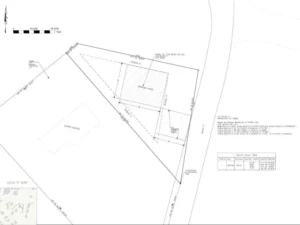
Permit reviewers at residential building departments are not architects or engineers evaluating design quality. They’re checking compliance — running through a standardized checklist to verify that the drawing demonstrates what the zoning code requires before they can approve the application.
That process is more mechanical than most homeowners expect. A reviewer isn’t reading the plan as a whole picture. They’re checking specific elements, in roughly the same order every time, and flagging anything that’s missing or inconsistent. Understanding that order is what separates a plan that clears review from one that comes back with three corrections.
The Order Reviewers Work Through a Site Plan
Step 1: Property Identification
Before checking anything technical, the reviewer confirms the plan is for the right property. They look for the property address, the parcel or APN number, and the legal description if required. A plan with no address gets returned immediately — not because anything is wrong with the drawing, but because it can’t be matched to the permit application
Step 2: Scale and Orientation
Is the plan drawn to a stated scale? Does the north arrow exist? A plan labeled “1 inch = 20 feet” that doesn’t actually hold to that ratio when measured can’t be used to verify setback distances — which makes every subsequent check impossible. The north arrow matters because most zoning codes define setbacks by compass direction: “front yard” means the yard facing the street, which varies by lot orientation
Step 3: Boundary Dimensions
Do the lot dimensions on the plan match the recorded plat or deed? A discrepancy — even a small rounding difference — flags the plan for correction because all setback calculations derive from the boundary. A wrong boundary produces wrong setbacks.
Step 4: Existing Structures
What’s already on the lot, and is it shown correctly? The reviewer cross-references the plan against county records. A plan showing an empty lot when the county has a 1,800-square-foot house on record gets flagged instantly. Existing structures matter because zoning compliance is cumulative — the proposed project has to work within what’s already there.
Step 5: Setback Lines
Are the required setback lines drawn on the plan — not just stated in a note, but actually drawn as lines on the lot — with the proposed project sitting visibly inside them and the clearance distance labeled? This is the most commonly missing element across all residential permit types. Reviewers need to see the setback line, see the structure, and see the dimension between them. Implying compliance isn’t enough.
Step 6: Proposed Project Location and Dimensions
Where exactly is the proposed structure? Dimensioned to every relevant property line and to the nearest existing structure. Not “approximately here” — at scale, with labeled distances.
Step 7: Permit-Type-Specific Elements
After the universal elements above, the reviewer checks permit-type-specific requirements:
- Fence permits: Right-of-way line shown and cleared, fence height labeled, sight-line triangle on corner lots
- Pool permits: Overhead utility clearance, equipment setback, barrier notation, septic system location on private-septic properties
- Shed permits: Separation distance from the house, lot coverage calculation
- Addition permits: Updated lot coverage, FAR calculation where applicable
- ADU permits: Separation distance, parking layout, utility connection routing
Step 8: Lot Coverage Calculation
On any permit type that adds impervious surface, the reviewer checks the coverage math. Existing coverage plus proposed addition, expressed as a percentage of the lot area. If the number exceeds the zoning district’s maximum, the application cannot be approved regardless of how accurate the rest of the plan is.
What "To Scale" Actually Means and Why It Matters
A plan is “to scale” when the ratio of drawn distances to real distances is consistent throughout. If 1 inch on the plan equals 20 feet on the ground, then every inch on the plan represents exactly 20 feet — not approximately 20 feet, and not 20 feet in some places and 18 feet in others.
Reviewers verify scale by measuring dimensions on the plan and checking them against the labeled dimensions. A plan that labels a setback as 10 feet but only measures 8 feet at the stated scale has an inconsistency the reviewer will flag. This is why freehand sketches almost always fail — not because they look bad, but because they can’t hold a consistent scale.
The Difference Between a Note and a Drawn Element
A common source of rejection that surprises homeowners: writing “10 ft setback maintained” in a note box on the plan is not the same as drawing the setback line 10 feet from the property line and showing the structure inside it.
Reviewers verify from drawn elements, not from written assertions. The note may be accurate, but the reviewer can’t verify it without the drawn element to measure. Notes are supplementary. Drawn, dimensioned elements are what reviewers check against.
Why Lot Coverage Trips Up Even Good Plans
A homeowner submits a carefully drawn plan for a deck addition. Lot boundaries are correct, scale is consistent, proposed deck is dimensioned to all property lines, setback lines are shown. The plan comes back: “Lot coverage calculation required.”
The plan looked complete. But in any jurisdiction that enforces a lot coverage maximum — a cap on total impervious surface as a percentage of the lot — the reviewer can’t approve an addition permit without verifying the coverage math. That calculation requires knowing the area of the house, the garage, the driveway, the patio, and the proposed addition, all added together and divided by the lot area.
None of that information is on the plan itself if you only drew the proposed project and the boundary.
Frequently Asked Questions
A: In order: property identification (address, APN), stated scale and north arrow, boundary dimensions matched to the recorded deed, existing structures shown, setback lines drawn with the proposed project dimensioned inside them, permit-type-specific elements (utility clearances, barrier notation, lot coverage), and any calculation required by the zoning district.
A: The most common reason is that the plan doesn’t prove the project is in the right place — the setback lines aren’t drawn, the distances aren’t labeled, or a required element (lot coverage, right-of-way line, separation distance) is missing. Being in the right place and demonstrating compliance are different things.
A: A property line is the legal boundary of your lot. A setback line is the minimum distance from the property line where a structure is allowed to sit — drawn as a second line inside the property boundary. Both need to appear on the plan.
A: Most permit offices accept common residential scales: 1″=10′, 1″=20′, or 1″=30′ are standard. What matters is that the stated scale is consistent throughout the drawing and can be verified by measurement.