
Waxahachie's permit picture splits cleanly into two categories: the historic district around the courthouse square with its older, irregular lots and established trees, and the new subdivisions spreading across Ellis County farmland as the city absorbs Dallas-Fort Worth's southward growth. Both need a site plan. Neither needs a licensed surveyor for a standard fence. From $89.
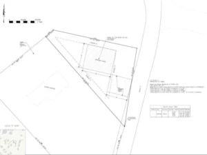
Waxahachie has spent the last decade absorbing a meaningful share of the population pushing south out of Dallas and Fort Worth along I-35E, while still holding onto its identity as the Ellis County seat with a genuinely historic downtown. That split shows up directly in how fence permits get processed.
A homeowner in one of the newer subdivisions off Highway 287 is dealing with standard suburban lot geometry, a likely HOA, and rear-yard drainage easements typical of recently platted Texas development. A homeowner two blocks from the courthouse square is dealing with a much older lot — sometimes platted before the city had a formal zoning code — where the right-of-way, the actual buildable area, and even the lot’s exact boundary can carry more ambiguity than a newer parcel ever would.
Both situations need a scaled site plan for the fence permit application. The starting data is different.
What Waxahachie's Building Department Checks on a Fence Permit Site Plan
Lot boundaries from Ellis County Appraisal District records. This is the baseline for every fence permit plan regardless of which part of the city the property sits in — boundary dimensions pulled from the recorded plat, not a satellite estimate.
Right-of-way line. Waxahachie’s older streets near downtown often carry ROW dedications that don’t match what a modern resident assumes their front yard boundary is. The newer subdivisions generally have more standardized ROW widths, but corner lots and lots along collector roads still need this checked individually.
Proposed fence location with setback dimensions. Drawn at scale, dimensioned to the nearest property line for every yard the fence crosses.
Fence height labeled. Front yard limits are lower than rear and side yard limits under Waxahachie’s zoning ordinance — confirm the specific figures for your zoning classification, since historic district properties sometimes carry additional design review on top of the standard height rule.
Existing structures. The house and any existing accessory buildings, shown at their actual location — which matters more on older lots where structures may not match current county GIS mapping exactly.
Recorded easements. Ellis County parcel records show utility and drainage easements. In Waxahachie’s newer subdivisions, rear drainage easements are common. In the older sections of town, utility easements sometimes date to infrastructure installed decades before modern easement documentation conventions — these can be less visible in a quick records search and are worth checking carefully.
Properties Near the Historic District — What Changes
If your property sits within Waxahachie’s historic preservation district around the courthouse square, fence permits may involve an additional layer of design review beyond the standard zoning checklist — material, height, and style guidelines intended to preserve the area’s architectural character. This review is separate from the site plan’s zoning compliance function; it concerns the fence’s design and appearance, not its location on the lot.
Confirm whether your property falls inside the historic district boundary before finalizing fence design. The site plan itself still needs to show the same elements as any other fence permit application — boundary, ROW, setbacks, height — but the design itself may need separate sign-off.
Newer Subdivisions and HOA Layering
Waxahachie’s growth corridor along 287 and toward Midlothian has brought in HOA-governed subdivisions with their own architectural standards for fence materials, colors, and heights — sometimes stricter than the city’s own limits. HOA approval runs separately from the municipal permit. Get both, and don’t assume one substitutes for the other.
Does Waxahachie Require a Surveyor for a Fence Permit?
No. A non-certified scaled site plan drawn from Ellis County parcel data is what Waxahachie’s Building Department accepts for a standard residential fence permit. This holds for both historic district properties and newer subdivision lots — the design review that applies to historic properties is a separate process from the surveying question, and neither requires a licensed surveyor’s stamp on the site plan itself.
If there’s a genuine boundary uncertainty on an older historic-area lot — which happens more often there than on a recently platted suburban parcel — a licensed survey may be worth considering independent of the permit requirement, simply for your own clarity on where the line sits.
Pricing
Basic Interior Lot — $89 Ellis County parcel data, ROW line, fence location with setback dimensions, height labeled, existing structures, easement check. PDF in [insert turnaround].
Historic District Property — $119 Additional boundary verification on older lots, ROW research for pre-zoning-code platted streets.
Corner Lot — $159 Two ROW lines, sight-line triangle.
Frequently Asked Questions
A: Yes. Waxahachie’s Building Department requires a fence permit for residential fences, with a site plan as part of the application.
A: It may add a design review layer for material, height, and style compatible with the historic district’s character. The site plan’s zoning compliance requirements — boundary, ROW, setbacks — are the same regardless. Confirm with the Building Department whether your specific property falls inside the historic preservation boundary.
A: Yes, for both historic-area and newer subdivision properties. A non-certified scaled drawing is accepted. No licensed surveyor’s stamp is required for a standard residential fence permit.
A: Older platted lots near downtown sometimes carry more genuine boundary ambiguity than newer suburban parcels. We draw from the best available recorded data, but if there’s an active dispute or real uncertainty, a licensed survey may be worth considering independently of the permit process.