
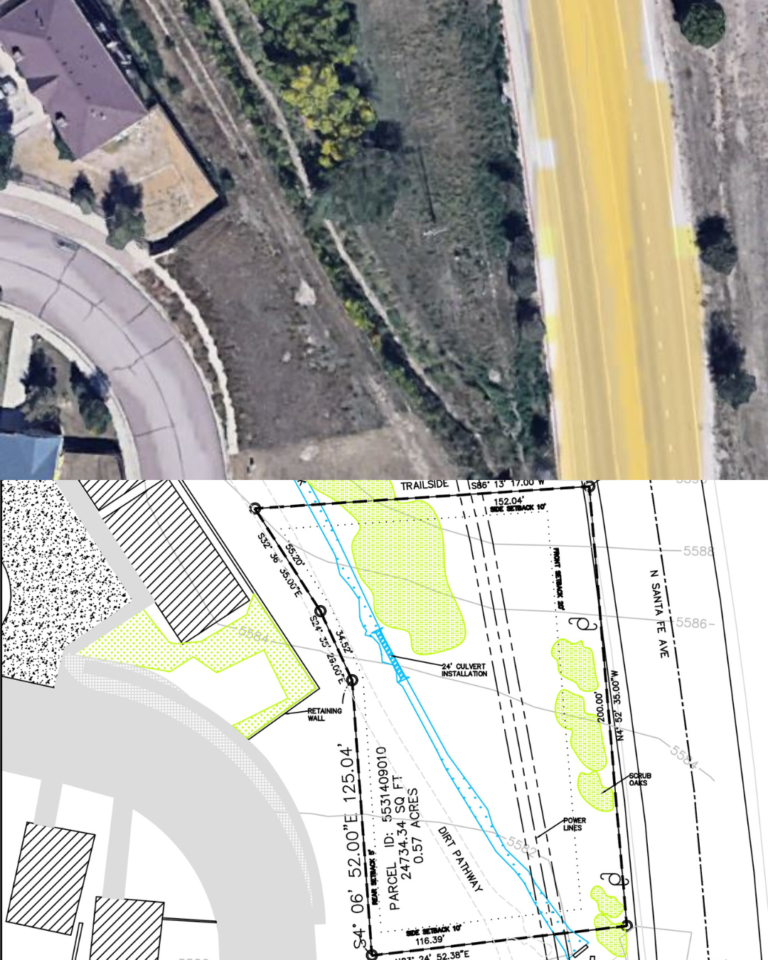
A plot plan for a residential building permit is a scaled drawing of your lot showing what exists, what's proposed, and how far everything sits from the property lines. Most permit offices accept a non-certified version for fences, sheds, pools, decks, additions, and ADUs. We draw it from your address. You get a PDF in days, not weeks.
- Free revisions if Planning & Inspections returns comments
- 24-hour turnaround for most residential Plot Plans
- Fixed price — $89 to $249
Most homeowners hit the same wall. The permit application is straightforward until the checklist reaches the line that says plot plan or site plan — and then everything stops. Some call a surveyor and get quoted $800 to $2,000 and a six-week wait. Some try to sketch something themselves and get it kicked back at the counter. Some just stall out completely, which means the contractor sits idle and the project slips.
A plot plan for a standard residential permit is not a licensed survey. It is a scaled, dimensioned drawing that shows your permit office what they need to see: where your property lines sit, where existing structures are, where the proposed project goes, and how all of it measures against the setback requirements in your zoning district. For fence permits, shed permits, pool permits, deck permits, addition permits, and most ADU permits, that drawing does not need a professional engineer’s stamp or a licensed surveyor’s signature in most U.S. municipalities. It needs to be accurate, legible, and to scale.
That is what we build — drawn from your parcel data and county GIS information, not traced from a satellite image and a guess.
What a Plot Plan for a Permit Actually Needs to Show
The specific requirements vary slightly by jurisdiction, but across thousands of residential permit submissions the same elements appear on nearly every checklist. A plot plan that gets accepted at the permit counter includes:
Property boundary lines with dimensions — the lot’s actual shape, drawn to a consistent scale, with the length of every boundary labeled. A plan without dimensions is one of the most common reasons a plot plan gets sent back before a reviewer even looks at the proposed work.
Setback lines — the minimum distances from property lines where structures are allowed to sit under your zoning district’s rules. The proposed project has to land clearly inside these lines, with the distance to the nearest property line labeled.
Existing structures — every building, structure, or improvement already on the lot: the house, any existing detached garage, sheds, pools, and hardscaped areas. Reviewers cross-reference these against county records. A plan that shows an empty lot when the parcel has a 2,400 sq ft house on it gets flagged immediately.
Proposed work location — where the new structure or project goes on the lot, dimensioned to the nearest property line and to any adjacent existing structure.
North arrow and scale bar — without both, a reviewer cannot orient the plan or verify any dimension. Plans missing a north arrow are returned at many permit offices as procedurally incomplete, regardless of how accurate the rest of the drawing is.
Street name and address — the lot has to be identifiable on its face. A plot plan with no address is not a plot plan for your property.
Driveway and access points — required by many municipalities for any permit that affects the front of the lot.
Some permit types add requirements on top of this base — pool permits often require showing the distance from the pool edge to the house, the septic system if applicable, and any overhead utilities. ADU permits typically require the distance between the primary dwelling and the accessory unit. Fence permits may require the height of the proposed fence labeled on the plan. We check your permit type against your municipality’s published checklist before drawing anything.
Why Plot Plans Get Rejected — and What Permit Offices Are Actually Looking For
A plot plan rejection is rarely about the quality of the drawing. It is almost always about one of these:
Dimensions that don’t add up. If the lot boundary dimensions on your plot plan don’t match the dimensions in your recorded deed, a reviewer will flag the discrepancy. This happens when a plot plan is drawn from a GIS screenshot without cross-referencing the actual deed.
Missing setback lines. The plan shows where the proposed structure goes, but doesn’t show the setback line it has to clear. The reviewer cannot approve a plan that doesn’t demonstrate compliance — they won’t measure it themselves and approve it anyway.
Proposed structure labeled but not dimensioned. “New shed” written on a rectangle somewhere on the lot is not enough. The distance from that rectangle to the nearest property line, and to the nearest existing structure, both need to be on the plan.
Scale inconsistency. A plan labeled “1 inch = 20 feet” that doesn’t actually scale correctly when measured. Reviewers at busy permit offices will spot this quickly, and a plan that can’t be trusted at scale can’t be used to verify setback compliance.
Satellite image submitted as a plot plan. A Google Maps screenshot with hand-drawn additions is not a scaled plan. Most permit offices specifically exclude aerial images as substitutes for scaled drawings, even when they’re labeled with dimensions.
Existing structures missing. A plan that doesn’t show what already exists on the lot cannot demonstrate that the proposed addition doesn’t create a zoning violation in combination with what’s already there.
Every one of these is checkable before a plan goes out the door. We check all of them.
Plot Plan vs. Survey — The Difference That Saves You $1,200
A licensed boundary survey is a legal document prepared by a state-licensed land surveyor, establishing property lines with legal precision and carrying the surveyor’s professional stamp. It is required for some things — selling a property, resolving a boundary dispute, recording a subdivision plat, or obtaining title insurance.
It is not required for most residential building permits involving fences, sheds, pools, decks, carports, or accessory structures. Most permit offices that require a “plot plan” or “site plan” for these permit types are asking for a scaled drawing that shows compliance with setbacks — not a legal survey document.
The confusion costs homeowners real money. A boundary survey for a residential lot runs $500 to $2,000+ depending on location, lot size, and how long ago the property was last surveyed. It takes weeks to schedule. And for a fence permit or a shed permit, it delivers far more than the permit office asked for — at several times the cost and a fraction of the speed.
If your permit checklist says “plot plan,” “site plan,” “survey sketch,” “site sketch,” or “property drawing,” verify with your permit office whether a licensed survey is specifically required before spending $1,500 on one. In most cases for simple residential permits, it is not.
If your municipality specifically requires a licensed surveyor’s stamp, we will tell you upfront — we don’t take your money and deliver something a permit office won’t accept.
What's Included in a Done-For-You Plot Plan
- Scaled lot boundary drawn from your parcel’s recorded deed and county GIS data — not a satellite screenshot
- All existing structures located and dimensioned on the plan
- Proposed project placed and dimensioned to property lines and adjacent structures
- Setback lines shown and labeled per your zoning district
- North arrow, scale bar, and legend
- Street address, parcel number, and lot area
- Permit-type-specific additions: pool setbacks to house and utilities, ADU separation distances, fence height labels — whatever your permit type requires
- PDF delivered to your email, sized for standard permit office submission
- DWG source file available on request for projects going to a licensed engineer or surveyor for stamping
Pricing
Residential Plot Plan — $89 Fence permits, shed permits, deck permits, pool permits, patio permits, driveway permits, demolition permits, accessory structure permits.
Residential Plot Plan with ADU Layout — $159 Accessory dwelling unit permits, garage conversion permits, junior ADU permits. Includes proposed unit footprint, separation distances, and parking layout where required.
Addition or Renovation Plot Plan — $259 Home addition permits, room additions, attached garage additions. Includes proposed addition footprint dimensioned to all property lines and existing structure.
Revision / Correction Cycle [Unlimited Revision For City Chekcer/Reviewer Back and forth comments and Requests]
Turnaround [24Hrs Fast Delivery, 12 Hrs Rush Orders ]
How It Works
1. Send your property address and permit type — fence, shed, pool, deck, ADU, addition, or other. If you have your municipality’s permit checklist, include it.
2. We pull your parcel data, deed, and county GIS information. We check your municipality’s published plot plan requirements for your specific permit type.
3. We draw the plan — lot boundaries, existing structures, proposed work, setbacks, and all required labels — to the scale and format your permit office expects.
4. You receive a PDF by email, ready to attach to your permit application. We answer any reviewer questions that come back.
Your permit checklist isn't going to fill itself in.
The permit office needs a scaled drawing. The contractor is waiting on the permit. The longer the plot plan sits undone, the longer everything behind it sits too
Frequently Asked Questions
A: In practice, most permit offices use these terms interchangeably for residential permits. A plot plan typically refers to a simpler drawing showing lot boundaries, existing structures, and the proposed project location. A site plan can imply a more detailed drawing that includes grading, drainage, and utilities. For most residential permits — fences, sheds, pools, decks — a plot plan and a site plan are the same document. We match what the checklist specifically calls for.
A: For most simple residential permits, no. Fence permits, shed permits, pool permits, deck permits, and addition permits in the majority of U.S. municipalities accept a non-certified scaled plot plan. A licensed surveyor’s stamp is generally required for subdivision platting, boundary dispute resolution, and some coastal or flood-zone projects. If your permit office specifically requires a licensed stamp, we’ll tell you before you pay — not after.
A: Accurate enough that a reviewer can verify your proposed project clears the required setbacks. That means dimensions that match your recorded deed, a consistent scale, and existing structures shown in their correct locations. It does not need to meet the legal precision standard of a licensed boundary survey.
A: Many municipalities allow owner-drawn plot plans for simple residential permits. The most common reasons a self-drawn plan gets rejected: wrong scale, missing setback lines, missing north arrow, dimensions that don’t match the deed, or existing structures not shown. If your permit type is simple and you’re comfortable with basic drafting, a self-drawn plan can work. If it gets rejected, the resubmission cycle costs more time than the original drawing would have.
A: Yes. Send us the correction letter or the reviewer’s notes and the original plan. We’ll correct the specific items flagged and get a revised version back to you. [Reivison within 24 Hrs cycles and resubmittals when requried]
A: Your property address and permit type is usually enough to start. If you have the permit application checklist from your municipality, include it — it tells us exactly what the reviewer will be looking for. For ADU and addition projects, dimensions of the proposed structure help.
A: Permit offices review the plan, not the preparer’s business model. A scaled, accurate plot plan that meets their checklist requirements will be accepted whether it was drawn by a local drafting service, an online service, or the homeowner. What gets rejected is a plan that’s missing required elements — not a plan that came from outside the area.
24 Hrs to 48Hrs, For urgent rush orders 12 Hours Delivery
A: Yes, All The Non certified Plot Plan And Non certified Site Plan accepting States.
A: Flood zone projects often require additional elements on the plot plan — base flood elevation, finished floor elevation, and distance to the floodplain boundary. These are permit-type-specific additions we include when the parcel is in a FEMA-mapped flood zone. If your permit office requires a full elevation certificate, that requires a licensed surveyor — we’ll flag that upfront.
The permit checklist is waiting. The contractor is waiting. Get the plot plan done.
Need a plot plan for a Building Permit in your city: see our plot plan services here