
Most fence permit rejections have nothing to do with the fence. They have to do with the drawing. Missing right-of-way clearance. No setback dimension to the property line. A lot boundary that doesn't match the recorded deed. We draw fence permit site plans from your parcel data — not from a satellite screenshot — and check the specific elements your permit office flags before the plan leaves our desk. From $89.
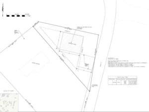
The correction letter comes back two weeks after submission. One line: “Site plan does not show required setback from right-of-way. Resubmit with corrected drawing.”
Two weeks gone. The fencing contractor rescheduled. The materials sitting in the driveway. And the correction itself takes twenty minutes to fix — if you know what a right-of-way setback is, where your right-of-way line actually runs, and how to show it correctly on a scaled plan.
Most homeowners don’t know those three things. That’s not a criticism — there’s no reason a homeowner should know where their municipality’s right-of-way terminates relative to their front property line. It’s recorded in the plat, cross-referenced against the deed, and varies street by street in older neighborhoods where roads were widened at different times over decades. The permit reviewer knows. The plan has to show it. That gap is where fence permit applications fail.
Do You Actually Need a Site Plan for a Fence Permit?
In most U.S. municipalities, yes. The specific term varies — some offices call it a site plan, some call it a plot plan, some call it a property survey sketch, some call it a location drawing — but the requirement is functionally the same: a scaled drawing showing your lot, where the proposed fence runs, and how far it sits from the boundaries and right-of-way lines that the zoning code regulates.
The jurisdictions that don’t require a drawing for a fence permit are generally smaller rural municipalities where fence permits are processed administratively rather than through a formal plan review cycle. If you’re in a suburb, an incorporated city or town, or any municipality with an active code enforcement program, expect a drawing requirement.
What that drawing needs to show is where most fence permit plans fall short.
Fence Permit site Plan in Arlington TX
Fence Permit site Plan in Plano TX
Fence Permit site Plan in Round Rock TX
What a Fence Permit Site Plan Has to Show — And What Gets Missed
Lot Boundaries With Correct Dimensions
The boundary on your plan has to match the dimensions in your recorded deed. Not the dimensions on Zillow. Not the measurements from a prior listing. The recorded deed.
Lot dimensions on real estate listing sites are frequently rounded, estimated, or derived from outdated records. A plan that shows a 75-foot front lot width when the recorded deed says 74.8 feet creates a dimension discrepancy a reviewer will flag — because the setback calculations derived from a wrong boundary are also wrong.
Every plan we deliver includes all of the above, plus the city-specific items your jurisdiction requires.
Right-of-Way Line Clearly Shown and Dimensioned
The right-of-way is the strip of land adjacent to a public street that the municipality owns or controls, typically used for utilities, sidewalks, and future road widening. In most jurisdictions, a fence cannot be built within the right-of-way — and in many, fences on the front of a lot must maintain a specific setback from the right-of-way line, not from the property line.
These are two different lines. In newer subdivisions with consistent street widths, they may be close together. In older neighborhoods, the right-of-way can extend several feet past the sidewalk onto what a homeowner believes is their yard.
A fence permit site plan that shows the fence location relative to the property line but doesn’t show the right-of-way line is missing one of the most commonly checked elements. Reviewers don’t assume the right-of-way is outside your property line — they want to see it drawn.
Proposed Fence Location With Dimensions to Property Lines
The fence has to be shown on the plan as a line — at the correct location, at scale — with a dimension from the fence to the nearest property line labeled. On corner lots, dimensions to both street-facing property lines are typically required because both frontages have setback rules.
Existing Structures
The existing house, any detached structures, and any existing hardscaping that affects coverage calculations need to appear on the plan. A plan that shows only the lot outline and the proposed fence line, with no existing structures shown, looks incomplete to a reviewer — because it is
Fence Height Labeled
Many municipalities regulate fence height differently by location: rear yard fences are often allowed up to 6 feet, front yard fences up to 4 feet, with sometimes a different rule for side yards depending on whether they’re interior or street-facing. The proposed fence height needs to be labeled on the plan — not just on the permit application form.
Easements That Affect Fence Placement
Utility easements recorded on the property — drainage easements, sewer easements, overhead powerline easements — often prohibit permanent structures including fences within a specified width. A fence placed over a utility easement will be flagged during plan review if the easement is shown on the county records, and will be subject to removal if discovered during utility maintenance even if the permit was somehow approved.
We check recorded easements against your parcel data before drawing the fence location. If an easement conflicts with your proposed fence line, we flag it in the plan notes — not in a correction letter six months later.
Sight-Line Triangle on Corner Lots
Corner lot fence permits almost always require a sight-line or sight-distance triangle — a clear zone at the intersection of two streets where fence height is restricted or fences are prohibited entirely, to maintain driver visibility. The dimensions of this triangle vary by municipality and sometimes by street classification. Missing it on a corner lot fence permit plan is one of the most predictable rejection reasons there is.
The Four Most Common Fence Permit Site Plan Rejections
1. Right-of-way not shown. Already covered above — but worth listing first because it’s the single most common correction on fence permit plans. Not drawn, not dimensioned, not labeled. One missing line that sends the application back.
2. Fence shown extending into an easement. The homeowner didn’t know about the easement. The plan drafter pulled dimensions from a satellite image that doesn’t show easement boundaries. The reviewer checks the county records, sees the utility easement running parallel to the rear property line, and kicks it back.
3. Corner lot sight-line triangle missing. Predictable, preventable, and disproportionately common because corner lot owners often don’t know the requirement exists until the correction letter arrives.
4. Dimensions inconsistent with the recorded deed. The plan shows a boundary dimension that doesn’t match what was recorded when the lot was platted. Not a big discrepancy — sometimes just a foot or two — but enough to make a reviewer question the accuracy of the setback dimensions derived from it.
Fence Permits That Are Straightforward — and Ones That Aren't
Straightforward: Standard interior lot, residential zoning, proposed fence runs along rear and side property lines at standard heights. No easements in conflict, right-of-way clearly established from the plat, no HOA overlay.
More involved:
Corner lots. Two street frontages, two sets of setback rules, a sight-line triangle, and sometimes different height restrictions on each frontage. Not complicated in terms of drafting — but the number of required elements is higher than an interior lot.
Properties with existing easements crossing the rear or side yard. Common in neighborhoods with older utility infrastructure, drainage channels, or properties that were subdivided from larger agricultural tracts. Easement boundaries need to be shown; the fence line needs to clear them.
Fence permits in flood-regulated areas. Some jurisdictions restrict solid fencing in FEMA-mapped flood zones because it impedes flow. A site plan in a flood zone may require showing the base flood elevation and demonstrating that the fence design complies with the local floodplain management ordinance. This is not standard on most fence permits — but it applies to more properties than homeowners expect.
HOA-governed subdivisions. If the property is in a recorded HOA with deed restrictions on fence materials, height, or location, HOA approval is typically a separate requirement from the municipal permit. The municipal permit site plan doesn’t reflect HOA rules — those are private covenants, not zoning regulations — but failing to check HOA restrictions before submitting the permit application creates a different problem after the permit is issued.
Pricing
Fence Permit Site Plan — $89 Interior residential lots. Standard fence permit requirements. PDF delivered in [insert turnaround]. No site visit required.
Corner Lot Fence Permit Site Plan — $119 Two street frontages, sight-line triangle, multiple setback zones. Higher element count than a standard interior lot.
Fence Permit in Flood Zone — $259 Additional floodplain overlay, base flood elevation notation, and flood-flow compliance check where required by local floodplain management ordinance.
Revision / Correction Cycle — [Unlimited Revision Upon City New Request and amendments for city Comments]
How much a Site Plan Cost in 2026 , find here
How the Process Works
Step 1. Send your property address, proposed fence location description (rear yard, full perimeter, front yard partial), and your municipality’s fence permit checklist if you have it.
Step 2. We pull your parcel boundary from the recorded deed, check for easements on the county’s GIS records, verify the right-of-way line from the plat, and confirm your zoning district’s fence setback and height rules.
Step 3. We draw the plan — lot boundaries, existing structures, easements, right-of-way line, proposed fence location, all required dimensions and labels — at the scale your permit office expects.
Step 4. You receive a PDF by email. Submit it with your permit application. If the reviewer asks for a correction, send us the note and we handle the revision.
What We Check That Most People Miss
Before drawing a single line, we verify:
- Recorded deed dimensions vs. GIS parcel data — flag any discrepancy before it becomes a reviewer’s correction
- Easements on record from the county — utility, drainage, sewer, access
- Right-of-way line location from the recorded subdivision plat
- Zoning district fence height rules — rear, side, front, and street-side if corner lot
- Corner lot sight-line triangle requirement and dimensions per the municipality’s traffic engineering standards
- Flood zone overlay from FEMA maps — if applicable, what additional documentation the permit office requires
- Any municipality-specific format requirements — sheet size, title block, scale notation, north arrow convention
Frequently Asked Questions for Fence Permit Site Plan Your Order
A: In most incorporated U.S. cities and suburbs, yes. The specific term varies — site plan, plot plan, property sketch — but the requirement is a scaled drawing showing the lot, existing structures, and proposed fence location. Smaller rural municipalities sometimes don’t require a drawing. Download your city’s fence permit application and check the requirements list.
A: Sometimes. If your survey is recent, shows current structures, and clearly shows the right-of-way line and any easements, some permit offices will accept it with the proposed fence marked on it. Call your permit office and ask specifically — don’t assume either way. If they want the fence shown at scale with setback dimensions labeled, a survey without those additions won’t clear review.
A: The correction letter will tell you specifically what’s missing. Send it to us. We correct the flagged items and return a revised plan. Most fence permit corrections are single-element fixes — one missing dimension, one unlabeled setback — that take less time to correct than the resubmission queue takes to process.
A: This varies by municipality and by location on the lot. Rear and side yard fences in most residential zones can go directly on the property line or within inches of it. Front yard fences typically have a setback requirement — often matching the front setback of the zoning district, or a specific distance from the right-of-way line. Corner lot side yards facing a street are treated as front yards for setback purposes in many jurisdictions. Check your zoning district’s fence regulations specifically.
A: In the vast majority of residential fence permit jurisdictions, no. A non-certified scaled drawing prepared from parcel data is accepted. Licensed surveyor stamps are typically required for subdivision platting and boundary dispute resolution — not fence permits. If your permit checklist specifically says “certified survey required,” verify that with the permit office before paying for one.
A: The right-of-way is the strip of land adjacent to a public street that the municipality controls — used for utilities, sidewalks, and potential future road improvements. In most jurisdictions, you cannot build a permanent structure, including a fence, within the right-of-way. The right-of-way line is often several feet inside what homeowners think is their property line, particularly in front yards. A fence permit plan that doesn’t show and dimension the right-of-way line is missing a critical element in most jurisdictions.
A: Yes. What a neighbor did without a permit doesn’t change your municipality’s requirement. Unpermitted fences are subject to removal orders under most local codes, and they don’t create a precedent that exempts other properties from the requirement
A: Most zoning ordinances allow fences on or adjacent to property lines in rear and side yards regardless of neighbor agreement — it’s a zoning question, not a neighbor-consent question. Some shared fence installations have their own legal framework under state property law, but that’s separate from the permit requirement. The permit site plan shows your fence on your property; neighbor consent isn’t typically a permit office concern.
A: That depends entirely on your municipality’s permit office processing time, which varies widely. High-volume suburban permit offices during spring and summer often have 2–4 week processing queues. Smaller municipalities may process fence permits in a few days. The site plan itself is delivered in [24 Hrs] — the permit office timeline after that is outside our control, Because The Permit reviewers/Technician of City/County sometimes comes up wtih new Amendents in Laws and internal staffing reallcoations that can cause Delays totally out of Your and Our Control.
Corner Lot? Start Here — $119